|
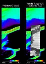
Mars’ South Polar Cap in Summer
- Click the image above for a larger view
- Full-Res JPEG (734 x 1024) (91.6 kB)
- Full-Res TIFF (734 x 1024) (886.6 kB)
Caption:
Simultaneous infrared and visible images taken by the camera system on NASA's Mars Odyssey spacecraft show the martian south polar cap in late summer. The black areas in the infrared image are at a temperature near -125 degrees Celsius (-193 degrees Fahrenheit) and correspond to solid carbon dioxide ice. The purple regions are areas of exposed water ice at a temperature near -95 degrees Celsius (-139degrees Fahrenheit). The warmest (red) areas are classic "dark lanes" of frost-free soil at a temperature near -55 degrees Celsius(-67 degrees Fahrenheit). The right panel shows the same infrared image with a visible image superimposed. The infrared image is approximately 32 kilometers (20 miles) wide.
Background Info:
The Jet Propulsion Laboratory, a division of the California Institute of Technology in Pasadena, manages the 2001 Mars Odyssey mission for NASA's Office of Space Science in Washington, D.C. Investigators at Arizona State University in Tempe, the University of Arizona in Tucson and NASA's Johnson Space Center, Houston, operate the science instruments. Additional science partners are located at the Russian Aviation and Space Agency and at Los Alamos National Laboratories, New Mexico. Lockheed Martin Astronautics, Denver, is the prime contractor for the project, and developed and built the orbiter. Mission operations are conducted jointly from Lockheed Martin and from JPL.
Cataloging Keywords:
| Name | Value | Additional Values |
|---|---|---|
| Target | Mars | |
| System | ||
| Target Type | Planet | |
| Mission | 2001 Mars Odyssey | |
| Instrument Host | Mars Odyssey | |
| Host Type | Orbiter | |
| Instrument | Thermal Emission Imaging System (THEMIS) | |
| Detector | ||
| Extra Keywords | Color, Infrared, Water | |
| Acquisition Date | ||
| Release Date | 2002-12-07 | |
| Date in Caption | ||
| Image Credit | NASA/JPL/ASU | |
| Source | photojournal.jpl.nasa.gov/catalog/PIA03743 | |
| Identifier | PIA03743 | |
