Southern rim of Isidis Planitia basin
Caption:
(Released 11 April 2002)
The Science
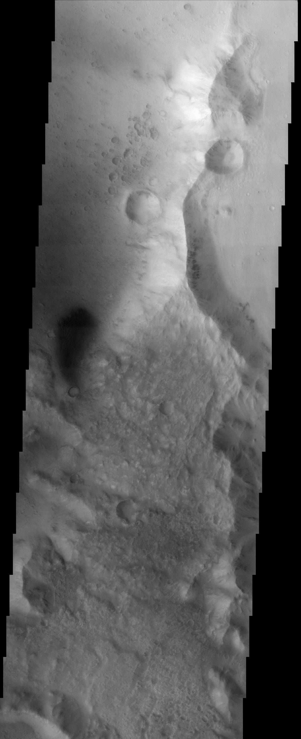
This image, crossing the southern rim of the Isidis Planitia basin, displays the contrasting morphologies of the relatively rough highland terrain (in the lower portion of the image) and the relatively smooth materials of the basin (at top). Upon closer viewing, the basin materials display an extensive record of cratering, including a small cluster of craters just north and west of the two prominent craters in the upper part of the image. This cluster of craters may represent what are called "secondary" craters, which are craters that form as a result of the ejection of debris from a nearby impact. Alternatively, these craters may have formed simultaneously by the impact of many pieces of a larger meteoroid that broke up upon entry into Mars' atmosphere. The large craters in the image are approximately 800 meters (~875 yards) in diameter. Also visible in the image are dark streaks on the east-facing side of the north-south trending ridge. These streaks are likely the result of debris movement down slope. A dark patch of material is visible at the left of the image; dark materials are typically mobile sands, and linear dune forms are apparent within the dark patch.
The Story
Battered and beaten up, the surface of Mars reads like a history book to geologists, who want to study what has happened to the red planet over its geological history. Look for two larger craters diagonal from one another in the northern part of this image, and then for the smattering of tinier craters near them. How did these smaller craters come to be? Did a large meteoroid streak in through the Martian atmosphere and get broken up as it passed through, pummeling Mars moments later with its smaller, scattered pieces? Or were rocks and dirt blasted off the surface when the two larger craters were formed, only to rain down again on Mars shortly afterwards? No one quite knows for sure....
Another enigmatic-looking feature is near the left center of this image. Dark and shadowy-seeming, it looks something like an exclamation point with the small crater just below it. Look closely, and you'll see dunes within the large, dark, blurry patch, which is itself probably composed of moving sands. Dark, streaky features also appear on the eastern side of the ridge that runs down the right side of the image, showing how debris once tumbled down its steepened slopes.
Cataloging Keywords:
| Name |
Value |
Additional Values |
| Target |
Mars |
|
| System |
|
|
| Target Type |
Planet |
|
| Mission |
2001 Mars Odyssey |
|
| Instrument Host |
Mars Odyssey |
|
| Host Type |
Orbiter |
|
| Instrument |
Thermal Emission Imaging System (THEMIS) |
|
| Detector |
|
|
| Extra Keywords |
Atmosphere, Crater, Dune, Grayscale, Impact, Rotation, Shadow |
| Acquisition Date |
|
| Release Date |
2002-05-21 |
| Date in Caption |
2002-04-11 |
|
| Image Credit |
NASA/JPL/Arizona State University |
| Source |
photojournal.jpl.nasa.gov/catalog/PIA03767 |
| Identifier |
PIA03767 |
