Auqakuh Valles
Caption:
(Released 7 June 2002)
The Science
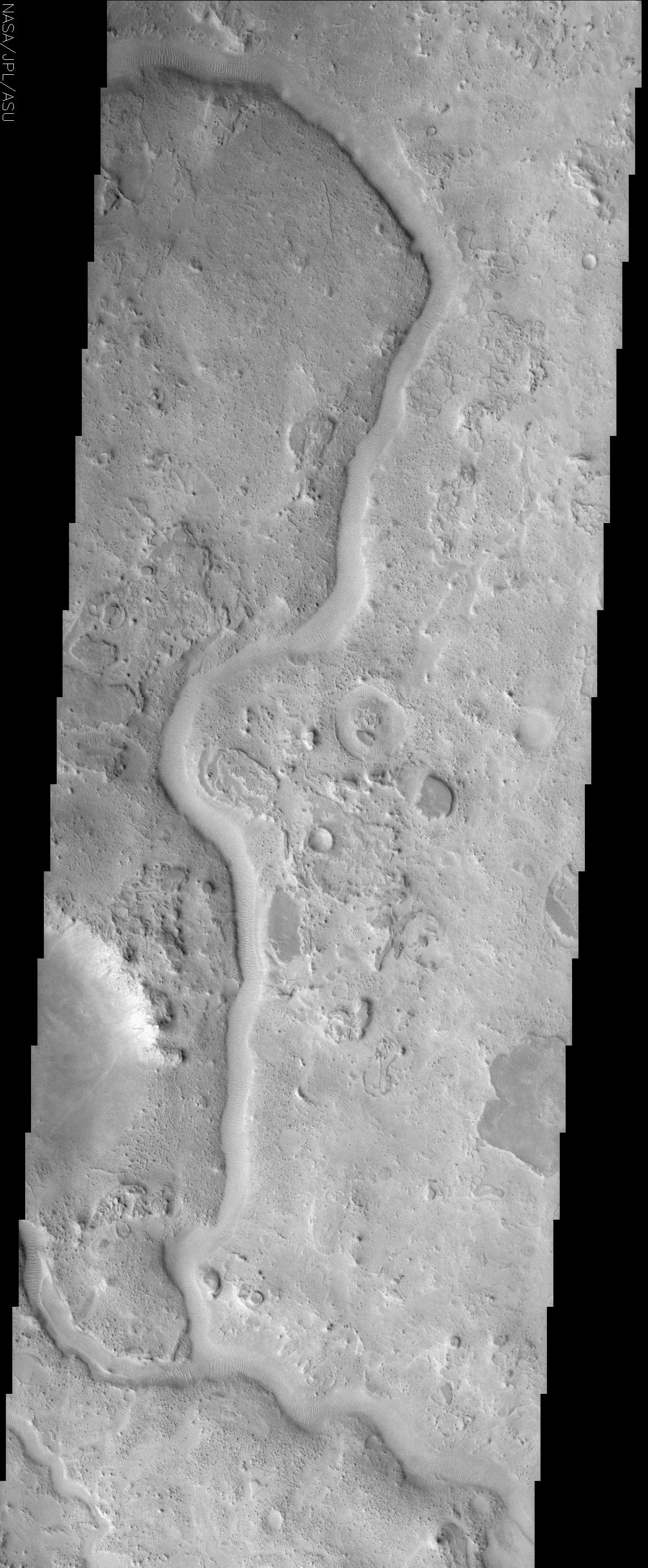
This ancient sinuous river channel, located near 30° N, 299° W (61° E), was likely carved by water early in Mars history. Auqakuh Valles cuts through a remarkable series of rock layers that were deposited and then subsequently eroded. This change from conditions favoring deposition to those favoring erosion indicates that the environment of this region has changed significantly over time. In addition, the different rock layers seen in this image vary in hardness, with some being relatively soft and easily eroded, whereas others are harder and resistant. These differences imply that these layers vary in their composition, physical properties, and/or degree of cementation, and again suggest that major changes have occurred during the history of this region. Similar differences occur throughout the southwest U.S., where hard rock layers, such as the limestones and sandstones in the Grand Canyon, form resistant cliffs, whereas softer mudstones are easily eroded to form broad slopes. The Martian layers, such as the smooth, dark-toned mesas visible in numerous places to the right (east) of the channel, were once continuous across the region. As these layers have eroded, they have produced a wide array of textures, from smooth surfaces, to knobby terrains, to the unusual lobate patterns seen in the upper right of the image.
The most recent activity in the region appears to be the formation of mega-ripples by the wind. These ripples, spaced approximately 75 m apart, form perpendicular to the wind direction, and can be seen following the pattern of the channel floor as it curves through this region. This pattern shows that even this relatively small channel, which varies in width from about 500 to 750 m throughout this image, acts to funnel the wind down the channel.
The Story
Auqakuh Vallis, an ancient river channel that winds its way down the center of this image, is the "fossil" remains of an earlier, probably more watery time in Martian history. Now, you might think that Auqakuh has something to do with Aqua, the Latin word for water. Instead, Auqakuh is the word for Mars in the Quechuan language of the Incan Empire that once stretched across vast portions of South America.
This Inca-honoring river channel cuts through a remarkable series of rock layers that expose a history of climate change in the region. The coarse, rugged, and wildly textured terrain was created as rock layers were first deposited, then eroded over time. Some of the rock layers are soft and easily eroded, while others are clearly harder and more resistant. From these differences, geologists can tell that the layers are made up of different materials, have different physical characteristics, and are either loosely or strongly cemented together. That suggests major environmental changes over time as well, since different kinds of rocks form under different conditions.
Similar differences in rock layers occur throughout the Southwest of the United States. The next time you're visiting the Grand Canyon or hiking in similar terrain, notice where hard rock layers, such as limestones and sandstones, form resistant cliffs, whereas softer mudstones are easily eroded to form broad slopes along the canyon.
Just in case the river channel in the above image looks more like a raised vein rather than a hollowed out channel, try looking at the half-circle depression on the left-hand side of the image, about a third of the way up. The bright features on the upper half streak down toward the bottom of the bowl. Once you focus on this for a while, your brain figures out that the channel must be depressed as well.
Now that you can see that the channel cuts into the surface, click on the image for a closer look at the bottom of the channel. Mega-ripples about 82 yards apart line the channel floor as it curves through the region. This pattern shows that even this relatively small channel, which varies from about one-third to a half of a mile in width, funnels the wind down its curving length, creating perpendicular piles of waving texture on the channel's floor.
East of the channel, smooth, dark-toned mesas are visible, providing a scant reminder that they were once continuous across the region. As these layers have eroded, they've produced a wide array of textures, from smooth surfaces, to knobby terrains, to the unusual curved, lobe-like patterns seen in the upper right of the image.
Cataloging Keywords:
| Name |
Value |
Additional Values |
| Target |
Mars |
|
| System |
|
|
| Target Type |
Planet |
|
| Mission |
2001 Mars Odyssey |
|
| Instrument Host |
Mars Odyssey |
|
| Host Type |
Orbiter |
|
| Instrument |
Thermal Emission Imaging System (THEMIS) |
|
| Detector |
|
|
| Extra Keywords |
Grayscale, Water |
| Acquisition Date |
|
| Release Date |
2002-06-17 |
| Date in Caption |
2002-06-07 |
|
| Image Credit |
NASA/JPL/Arizona State University |
| Source |
photojournal.jpl.nasa.gov/catalog/PIA03824 |
| Identifier |
PIA03824 |
