
|
New Gullies on Martian Sand Dune
- Click the image above for a larger view
- Full-Res JPEG (596 x 550) (48.5 kB)
- Full-Res TIFF (596 x 550) (328.4 kB)
Caption:
|

|
One of the many mysteries associated with martian geology is the origin of gullies found at latitudes poleward of 30 degrees latitude. Most of these gullies are found within craters or other depressions, and appear to be related to the bedrock. Several hypotheses have been proposed for their origin, including groundwater seepage and melting at the base of a dust-mantled snow pack.
Some middle-latitude gullies are found on sand dunes. These gullies appear to be different from those found on the slopes of craters, but generally have been interpreted to form by similar processes. In the present martian environment, it is difficult to introduce water to the surface. The temperature and atmospheric pressure may permit water to exist, but the rate of heating of the ground and atmosphere, and the amount of energy available to warm the ground or melt snow, are not conducive to such processes. An alternative process of gully formation on these sand dunes involves frozen carbon dioxide trapped in the winter by windblown sand, then subliming rapidly enough for the escaping carbon-dioxide gas to make the sand flow as a gully-cutting fluid.
As part of extended-mission science investigation using the Mars Orbiter Camera on NASA's Mars Global Surveyor spacecraft, the camera team is re-imaging many locations where previous observations revealed gullies. The intent is to see if gully-forming processes are operating on Mars at the present time.
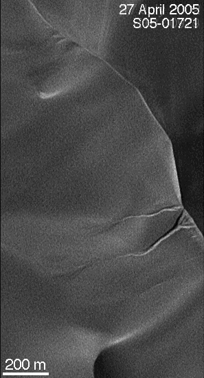
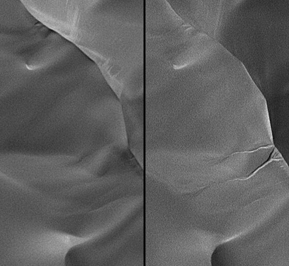
The team has found one location where a new gully formed on a dune in an unnamed crater in the Hellespontus region of Mars, west of the Hellas Basin. This pair of narrow-angle images ( figure 1 ) from the Mars Orbiter Camera shows the dune as it appeared on July 17, 2002, (left) and as it appeared on April 27, 2005, (right). The nearly three Earth years of intervening time amount to about 1.4 Mars years. During this period, a couple of gullies formed on the dune slip face. It is critical to recognize that the 2002 image was obtained at a time of year when the incident sunlight was coming in from a lower angle, relative to the horizon, than in the 2005 image. If the gullies had been present in 2002, their appearance would be sharper and more pronounced than they are in the 2005 image. The gullies simply did not exist on July 17, 2002. The steep walls of the gully alcove and channels suggests that the sand in this dune is somewhat cohesive, an observation common among martian sand dunes seen by the Mars Orbiter Camera over the past eight years.
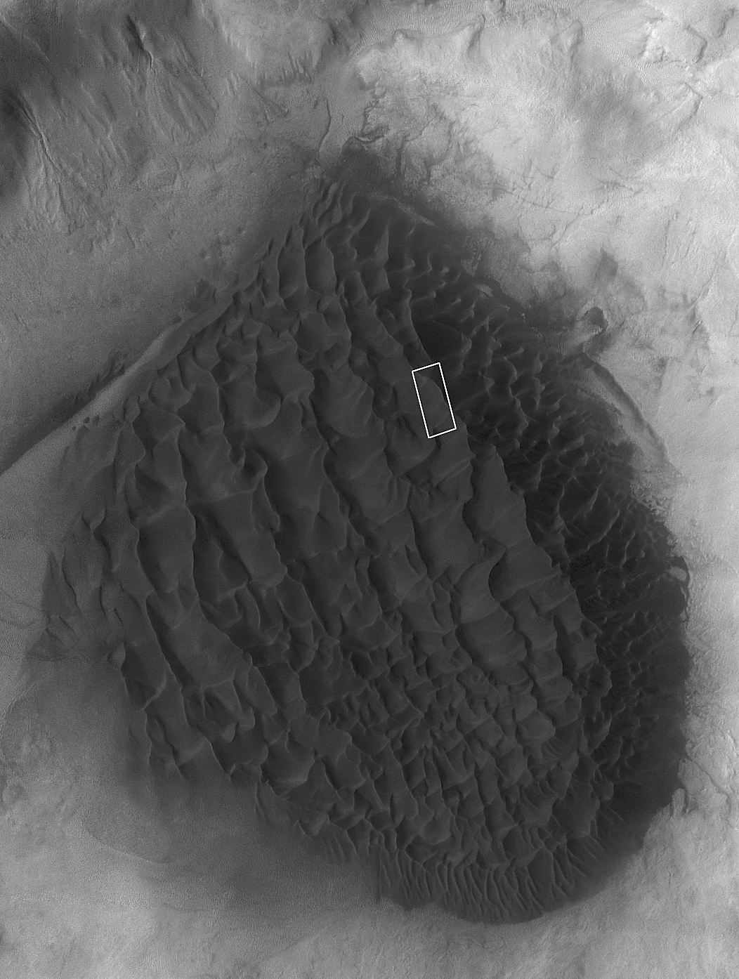
Wider context for the dune is shown in a mosaic of two images from the Thermal Emission Imaging System on NASA's Mars Odyssey orbiter ( figure 2 ), encompassing the dark-toned sand dune field on the floor of a crater located near 49.8 degrees south latitude, 325.4 degrees west longitude. In this image, north is approximately up and sunlight illuminates the scene from the upper left.
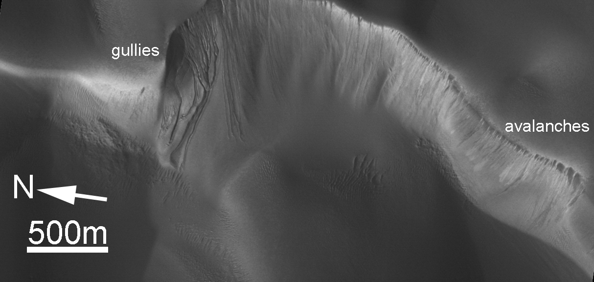
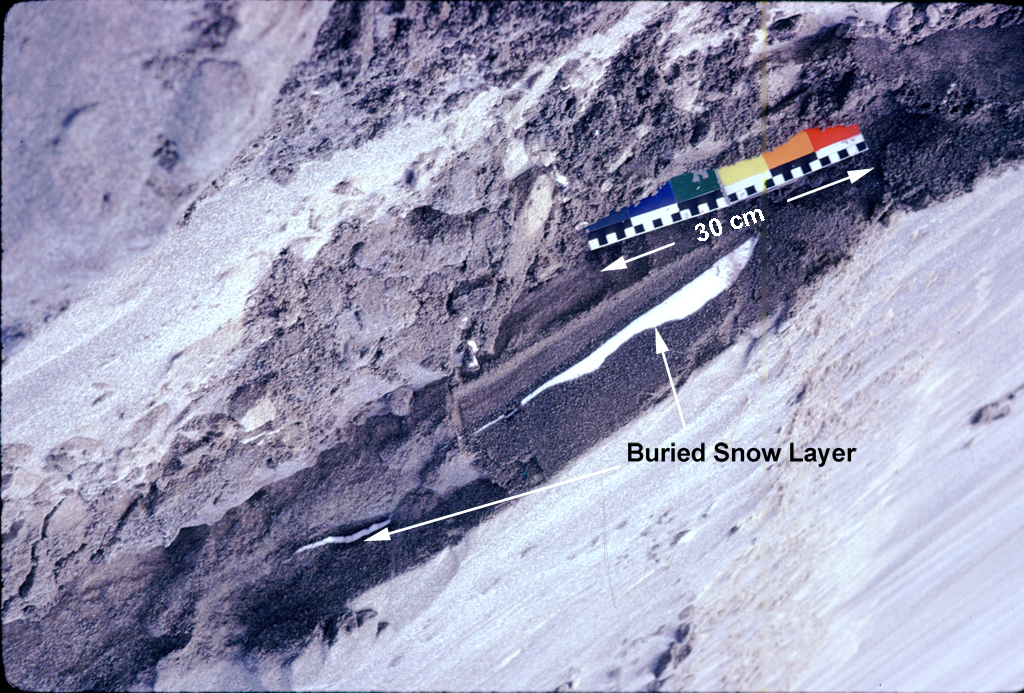
Based on earlier observations of other dune fields with gullies, camera-team scientists suspect that these gullies form by a process other than water fluidization. An image of a dune in Russell Crater, taken by the Mars Orbiter Camera in March 2001, ( figure 3 ) shows how the morphology of the dune's slip face changes with direction: Gullies form on pole-facing slopes (southwest in this case), while normal slip-face avalanche features ("avalanches" in the figure) are seen on the equator-facing slopes (northwest in this case). Most of the dunes that have gullies on them are located in the Hellespontus and Noachis regions, and are frost-covered during the winter. Based on experience in Antarctica and other cold regions on Earth, it is known that snow and ice can be incorporated into dunes during winter. An example is the layering of snow buried in a sand dune in Victoria Valley, Antarctica, seen in a photograph taken by Michael Malin during the austral summer of 1982-1983 ( figure 4 ). Active sand dunes in cold regions such as Antarctica and northern Canada commonly incorporate wintertime snow as new sand avalanches down a slip face and covers the frozen material. A similar process might occur for middle and high latitude dunes on Mars, although in many cases the "snow" would consist mostly of carbon-dioxide frost, with minimal water ice.
What would happen to carbon-dioxide frost incorporated into a martian sand dune? On surfaces that receive early and direct sunlight, the sand would heat and the carbon-dioxide frost would sublime over a period of time, undermining the slope and promoting normal sand sliding. On slopes that were initially shaded and later exposed to direct sunlight, heating would be delayed and the carbon dioxide frost would sublime rapidly. This rapid formation of carbon-dioxide gas may act to fluidize overlying sand, causing it to flow rather than avalanche, and thus create a gully.
Background Info:
The Mars Orbiter Camera was built and is operated by Malin Space Science Systems, San Diego, Calif. Mars Global Surveyor left Earth on Nov. 7, 1996, and began orbiting Mars on Sept. 12, 1997. JPL, a division of the California Institute of Technology, Pasadena, manages Mars Global Surveyor for NASA's Science Mission Directorate, Washington.
Cataloging Keywords:
| Name | Value | Additional Values |
|---|---|---|
| Target | Mars | |
| System | ||
| Target Type | Planet | |
| Mission | Mars Global Surveyor (MGS) | 2001 Mars Odyssey |
| Instrument Host | Mars Global Surveyor | Mars Odyssey |
| Host Type | Orbiter | |
| Instrument | Mars Orbiter Camera (MOC) | |
| Detector | ||
| Extra Keywords | Atmosphere, Crater, Dune, Dust, Grayscale, Thermal, Water | |
| Acquisition Date | ||
| Release Date | 2005-09-20 | |
| Date in Caption | 2002-07-17 | 2005-04-27 |
| Image Credit | NASA/JPL/MSSS | |
| Source | photojournal.jpl.nasa.gov/catalog/PIA04290 | |
| Identifier | PIA04290 | |