
|
Four Mars Years of South Polar Changes
- Click the image above for a larger view
 Movie Download Options
- Full-Res JPEG (968 x 1756) (158.1 kB)
- Full-Res TIFF (968 x 1756) (1.7 MB)
Caption:
|

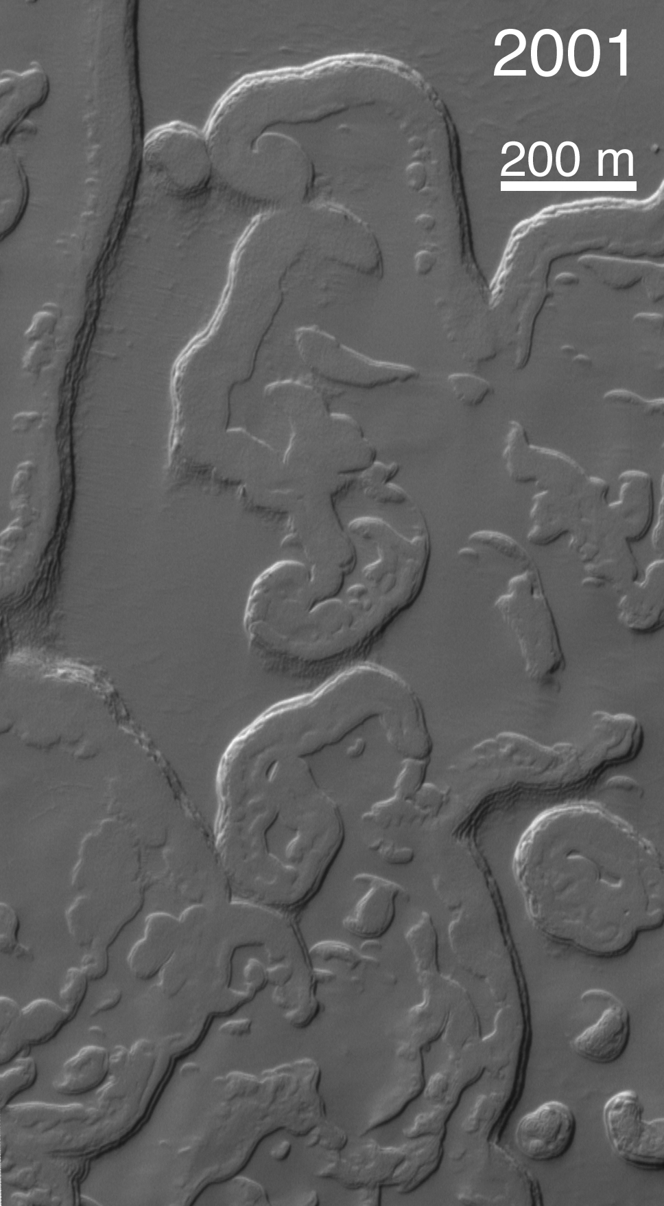
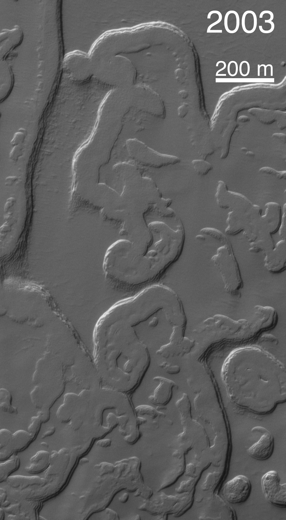
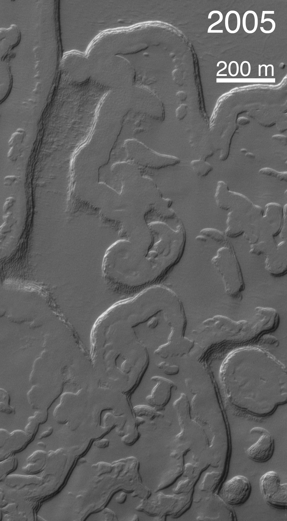
One of the most profound discoveries that would not have been possible if NASA's Mars Global Surveyor mission had not been extended beyond its primary mission of one Mars year (687 Earth days) is that of dramatic changes that take place in the south polar residual ice cap each martian year. To make this discovery, the Mars Orbiter Camera on the spacecraft had to be employed during a second Mars year to repeat images of sites on the south polar cap that had been imaged during the primary mission.
The initial discovery was made in 2001, when the camera team repeated images of portions of the south polar cap that had already been imaged in 1999. The goal of these images was to obtain stereo views, which would allow investigators to see the topography of the cap in three dimensions and to measure the thickness of the polar ice layers.
It was not possible to produce the desired 3-D views. To the team's surprise, the landforms of the south polar cap had changed.
The south polar residual cap -- that is, the portion of the ice cap that remains bright and retains ice throughout the southern summer season -- was seen in 1997 and 1999 images to have a complex terrain of broad, relatively flat mesas, small buttes, and many pits and troughs. Pits are generally circular and in some areas visually resemble a stack of thin slices of Swiss cheese. Very early in the Mars Global Surveyor mission, the Mars Orbiter Camera team speculated that these landforms must be carved into frozen carbon dioxide, because they look so unfamiliar and because Viking orbiter infrared measurements indicated that the south polar cap is cold enough consist of frozen carbon dioxide, even in summer.
The observations made by Mars Orbiter Camera in 2001, during the first part of the extended mission, showed that the scarps and pit walls of the south polar cap had retreated at an average rate of about 3 meters (10 feet) since 1999. In other words, they were retreating 3 meters per Mars year (and, of course, most of that retreat takes place during the summer). In some places on the cap, the scarps retreat less than 3 meters a Mars year, and in others it can retreat as much as 8 meters (26 feet) per martian year.
Of the two volatile materials one is likely to find in a frozen state on Mars -- water and carbon dioxide -- it is carbon dioxide that is volatile enough to permit scarp retreat rates like those observed by the Mars Orbiter Camera.
Over time, south polar pits merge to become plains, mesas turn into buttes, and buttes vanish forever. Since 2001, two additional Mars years have elapsed. A scientific benefit of having a long extended mission for Mars Global Surveyor has been the opportunity to document how the polar cap is changing each year.
Four images are shown here, plus an animation at left presenting the four frames in sequence. The location is near 86.3 degrees south latitude, 49.4 degrees west longitude, and the images show the same portion of the south polar residual cap as it appeared in 1999, 2001, 2003, and 2005. Comparing the images or viewing the animation makes it evident that the landscape of the south polar cap has been changing rapidly over the past four martian years.
Each year that Mars Global Surveyor has been in orbit, the landforms of the south polar residual cap have gotten smaller, and the carbon dioxide removed from the cap has not been re-deposited. The implication is that Mars presently has a warm (and possibly warming) climate, with new carbon dioxide going into the atmosphere every year. The other implication is that, at some time in the not-too-distant past, the planet had a colder climate, so that the layers of carbon dioxide could be deposited in the first place. If one takes the rate of scarp retreat and projects it backwards to fill in all of the pits and troughs with the carbon dioxide that has been removed from them, one finds that the colder climate might only have occurred a few centuries to a few tens of thousands of years ago. This kind of time scale is not unlike that of the climate changes that have been recorded on Earth, including the Ice Ages and the smaller fluctuations that have occurred since the last Ice Age (e.g., the "Little Ice Age" of the mid-14th through mid-19th centuries).
After the discovery that the pits were enlarging and that we were not seeing carbon-dioxide deposition, it was suggested that interannual variations might be large enough to permit such deposition on a short timescale. However, two Mars years of additional observations show no large magnitude annual differences. Variations that would permit carbon dioxide deposition may require decades. And to see such variations may require many more Mars years of observations by orbiting spacecraft.
Background Info:
The Mars Orbiter Camera was built and is operated by Malin Space Science Systems, San Diego, Calif. Mars Global Surveyor left Earth on Nov. 7, 1996, and began orbiting Mars on Sept. 12, 1997. JPL, a division of the California Institute of Technology, Pasadena, manages Mars Global Surveyor for NASA's Science Mission Directorate, Washington.
Cataloging Keywords:
| Name | Value | Additional Values |
|---|---|---|
| Target | Mars | |
| System | ||
| Target Type | Planet | |
| Mission | Mars Global Surveyor (MGS) | Viking |
| Instrument Host | Mars Global Surveyor | |
| Host Type | Orbiter | |
| Instrument | Mars Orbiter Camera (MOC) | |
| Detector | ||
| Extra Keywords | Atmosphere, Grayscale, Infrared, Movie, Water | |
| Acquisition Date | ||
| Release Date | 2005-09-20 | |
| Date in Caption | ||
| Image Credit | NASA/JPL/MSSS | |
| Source | photojournal.jpl.nasa.gov/catalog/PIA04295 | |
| Identifier | PIA04295 | |