
|
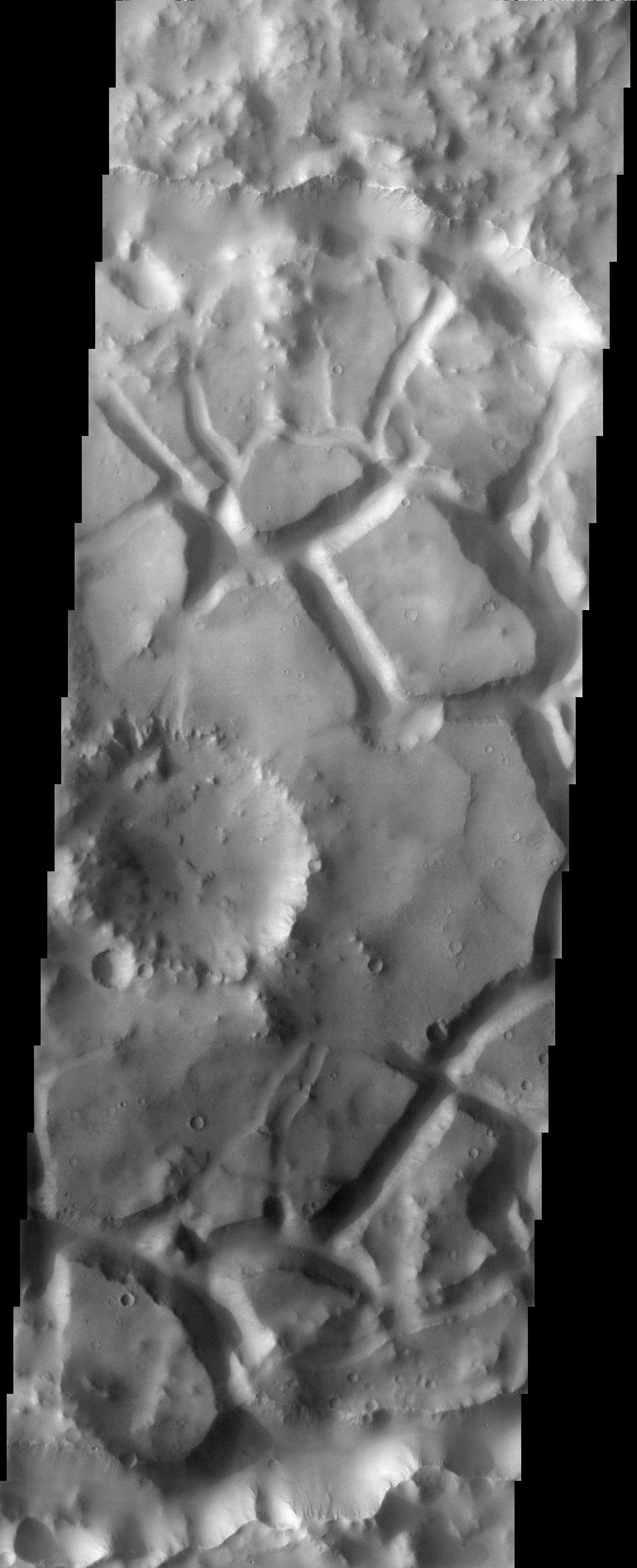
Chaotic Terrain
- Click the image above for a larger view
- Full-Res JPEG (1238 x 3043) (498.3 kB)
- Full-Res TIFF (1238 x 3043) (3.3 MB)
Caption:
Released 4 June 2003
Chaotic terrain on Mars is thought to form when there is a sudden removal of subsurface water or ice, causing the surface material to slump and break into blocks. The chaotic terrain in this THEMIS visible image is confined to a crater just south of Elysium Planitia. It is common to see chaotic terrain in the vicinity of the catastrophic outflow channels on Mars, but the terrain in this image is on the opposite side of the planet from these channels, making it somewhat of an oddity.
Image information: VIS instrument. Latitude -5.9°, Longitude 108.1° East (251.9%deg; West). 19 meter/pixel resolution.
Note: this THEMIS visual image has not been radiometrically nor geometrically calibrated for this preliminary release. An empirical correction has been performed to remove instrumental effects. A linear shift has been applied in the cross-track and down-track direction to approximate spacecraft and planetary motion. Fully calibrated and geometrically projected images will be released through the Planetary Data System in accordance with Project policies at a later time.
Background Info:
NASA's Jet Propulsion Laboratory manages the 2001 Mars Odyssey mission for NASA's Office of Space Science, Washington, D.C. The Thermal Emission Imaging System (THEMIS) was developed by Arizona State University, Tempe, in collaboration with Raytheon Santa Barbara Remote Sensing. The THEMIS investigation is led by Dr. Philip Christensen at Arizona State University. Lockheed Martin Astronautics, Denver, is the prime contractor for the Odyssey project, and developed and built the orbiter. Mission operations are conducted jointly from Lockheed Martin and from JPL, a division of the California Institute of Technology in Pasadena.
Cataloging Keywords:
| Name | Value | Additional Values |
|---|---|---|
| Target | Mars | |
| System | ||
| Target Type | Planet | |
| Mission | 2001 Mars Odyssey | |
| Instrument Host | Mars Odyssey | |
| Host Type | Orbiter | |
| Instrument | Thermal Emission Imaging System (THEMIS) | |
| Detector | ||
| Extra Keywords | Crater, Grayscale, Thermal, Water | |
| Acquisition Date | ||
| Release Date | 2003-06-12 | |
| Date in Caption | 2003-06-04 | |
| Image Credit | NASA/JPL/Arizona State University | |
| Source | photojournal.jpl.nasa.gov/catalog/PIA04556 | |
| Identifier | PIA04556 | |