|
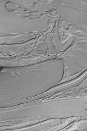
Hellas “Taffy Pull”
- Click the image above for a larger view
- Full-Res JPEG (512 x 768) (85.8 kB)
- Full-Res TIFF (512 x 768) (393.8 kB)
Caption:
MGS MOC Release No. MOC2-499a, 30 September 2003
Some of the strangest-looking surfaces on Mars occur in northwestern Hellas Planitia. Over the years, the Mars Global Surveyor (MGS) Mars Orbiter Camera (MOC) team has informally--quite informally--taken to calling these surfaces, "taffy-pull terrain." This image shows an example located near 39.2°S, 305.2°W. The origin of this pattern is unknown, although it is thought to be related to the erosion of different layers of bedrock or substrate of differing physical properties. That is, a hard layer would be more difficult to erode than a soft, or poorly-consolidated layer. However, layering and erosion alone probably do not explain these landforms; perhaps faulting or mass movement of debris also involved. As with all other explorations in our Solar System, sometimes the pictures we get back from space present us with more questions, rather than answers. This image covers an area 3 km (1.9 mi) across; sunlight illuminates the scene from the upper left.
Cataloging Keywords:
| Name | Value | Additional Values |
|---|---|---|
| Target | Mars | |
| System | ||
| Target Type | Planet | |
| Mission | Mars Global Surveyor (MGS) | |
| Instrument Host | Mars Global Surveyor | |
| Host Type | Orbiter | |
| Instrument | Mars Orbiter Camera (MOC) | |
| Detector | ||
| Extra Keywords | Grayscale | |
| Acquisition Date | ||
| Release Date | 2003-09-30 | |
| Date in Caption | 2003-09-30 | |
| Image Credit | NASA/JPL/Malin Space Science Systems | |
| Source | photojournal.jpl.nasa.gov/catalog/PIA04771 | |
| Identifier | PIA04771 | |
