skip to navigation
|
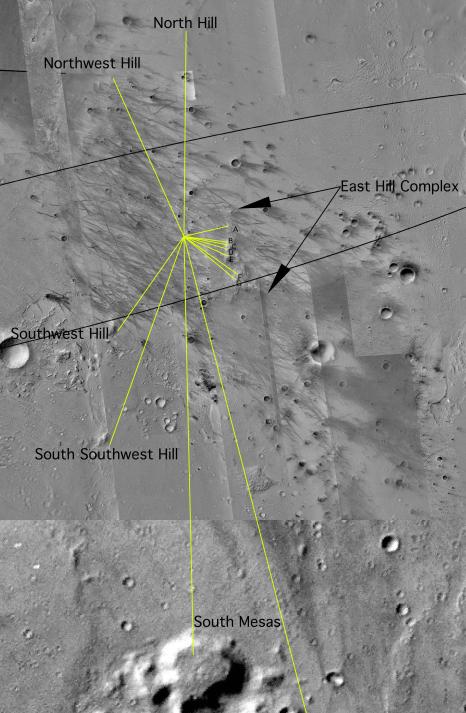
Map of Hills on the Horizon
- Click the image above for a larger view
- Full-Res JPEG (2996 x 4584) (2.0 MB)
- Full-Res TIFF (2996 x 4584) (19.2 MB)
Caption:
This overhead view maps the Mars Exploration Rover Spirit's approximate location in relation to nearby craters and hills. By combining images from both the camera on Mars Global Surveyor and the descent image motion estimation system camera located on the bottom of the rover's lander, scientists and engineers can tell how far away the hills are from the rover. This information would be more difficult to obtain from the panoramic images. The hills and hill ranges are marked by yellow lines, and the rover is located where the yellow lines intersect. Black arrows locate the east hill complex, a potential rover destination.
Cataloging Keywords:
| Name | Value | Additional Values |
|---|---|---|
| Target | Mars | |
| System | ||
| Target Type | Planet | |
| Mission | Mars Global Surveyor (MGS) | Mars Exploration Rover (MER) |
| Instrument Host | Mars Global Surveyor | Spirit (MER-A) |
| Host Type | Orbiter | Rover |
| Instrument | Descent Image Motion Estimation System (DIMES) | Mars Orbiter Camera (MOC) |
| Detector | ||
| Extra Keywords | Color, Crater, Map | |
| Acquisition Date | ||
| Release Date | 2004-01-13 | |
| Date in Caption | ||
| Image Credit | NASA/JPL/MSSS | |
| Source | photojournal.jpl.nasa.gov/catalog/PIA05059 | |
| Identifier | PIA05059 | |