Virtual Rover Drives Toward Rock
Caption:
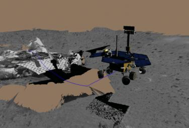
This image shows a screenshot from the software used by engineers to test and drive the Mars Exploration Rover Spirit. The software simulates the rover's movements across the martian terrain, helping to plot a safe course. Here, engineers simulated Spirit's first post-egress drive on Mars Sunday. The 3-meter (10-foot) drive totaled approximately 30 minutes, including time to stop and take images. The rover drove toward its first rock target, a mountain-shaped rock called Adirondack. The blue line denotes the path of the rover's "belly button," as engineers like to call it, as the rover drove toward Adirondack. The virtual 3-D world around the rover was built from images taken by Spirit's stereo navigation cameras. Regions for which the rover has not yet acquired 3-D data are represented in beige.
Cataloging Keywords:
| Name |
Value |
Additional Values |
| Target |
Mars |
|
| System |
|
|
| Target Type |
Planet |
|
| Mission |
Mars Exploration Rover (MER) |
|
| Instrument Host |
Spirit (MER-A) |
|
| Host Type |
Rover |
|
| Instrument |
Navigation Camera (Navcam) |
|
| Detector |
|
|
| Extra Keywords |
Color, Mountain |
| Acquisition Date |
|
| Release Date |
2004-01-19 |
| Date in Caption |
|
|
| Image Credit |
NASA/JPL |
| Source |
photojournal.jpl.nasa.gov/catalog/PIA05101 |
| Identifier |
PIA05101 |

