|
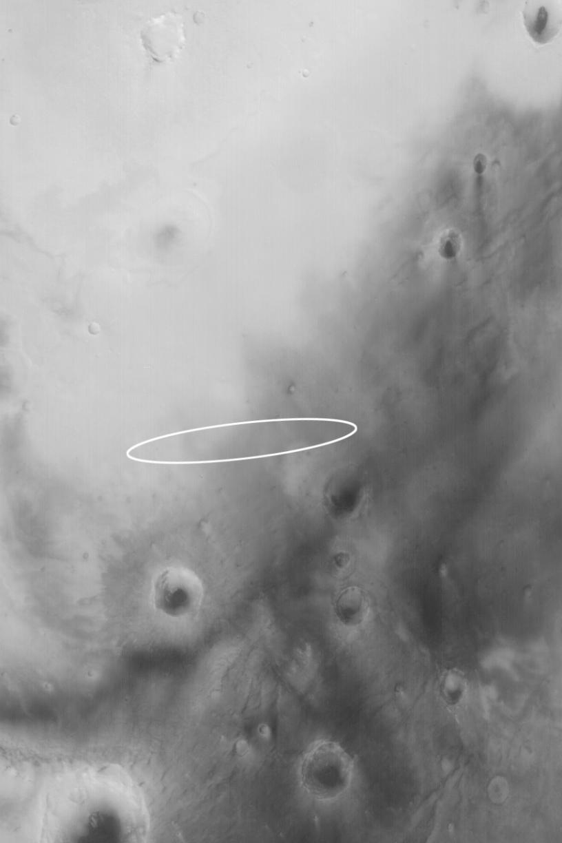
Mars Exploration Rover (MER-B) Opportunity Landing Site
- Click the image above for a larger view
- Full-Res JPEG (853 x 1280) (56.8 kB)
- Full-Res TIFF (853 x 1280) (879.3 kB)
Caption:

Mosaic (Click on image for larger view)

Wide Angle View (Click on image for larger view)
Narrow Angle View (Click on image for larger view)
24 January 2004
The second Mars Exploration Rover (MER-B), Opportunity, is set to land on Mars around 9:05 p.m. Pacific Standard Time today, 24 January 2004 (25 January 2004 UTC). Above are shown three perspectives on the Opportunity landing site, which is an ellipse in Meridiani Planum approximately 87 km (54 mi) long by 11 km (6.8 mi) wide. All images are oriented with north up and east to the right. The lander will be coming through the atmosphere from the west/southwest, roughly following the long axis of the ellipse. It is most likely to touch down somewhere near the center of the ellipse.
The first image (top) is a mosaic of MGS MOC and Mars Odyssey Thermal Emission Imaging System visible images (THEMIS-VIS). The THEMIS-VIS instrument provides pictures with a spatial resolution of 18 meters per pixel (~59 ft/pixel); the MOC images used in the mosaic have resolutions ranging from 1.4 m/pixel to 12 m/pixel. A total of 15 THEMIS-VIS images were used to form the background, on which 61 MOC high resolution images were mosaiced. These data were acquired over a period spanning parts of 3 Mars years between April 1999 through January 2004. These pictures were acquired not only in different years, but in different seasons, so the illumination angle, overall brightness, and patterns of ephemeral windblown dust and, in some cases, dark dust devil streaks, are different from image to image within the mosaic.
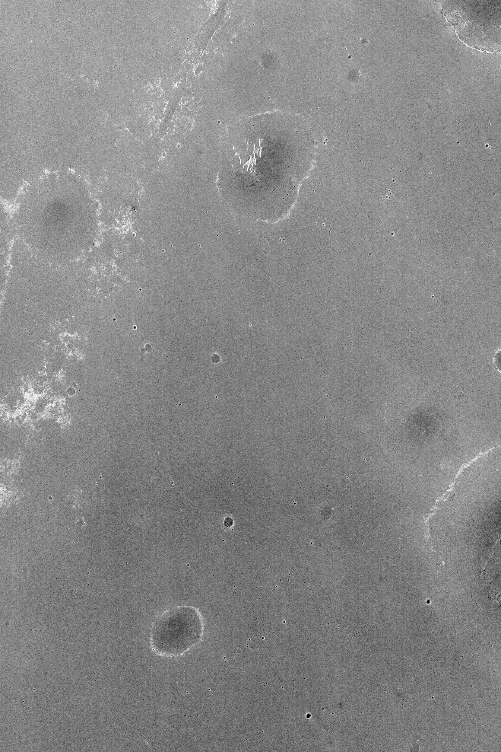
The second image (middle) is a Mars Global Surveyor (MGS) Mars Orbiter Camera (MOC) red wide angle view obtained in November 2003 as part of an on-going effort to monitor the weather at the landing site. The wide angle view provides a sense of the regional context. The third image (bottom) is a 1.8 m/pixel (6 ft/pixel) view near the center of the landing ellipse. It was also acquired by MOC in November 2003, and covers an area 3 km (1.9 mi) wide. The light-toned, somewhat circular features are believed to be either the location of ancient, buried, nearly-filled meteor impact craters or the eroded remains of craters that formed in bedrock that has long since been removed from the region.
The Opportunity landing site in Meridiani Planum was selected to provide access, it is hoped, to materials bearing the iron oxide mineral, hematite. Hematite was detected in this region by the Thermal Emission Spectrometer (TES) on MGS. This mineral is suspected of providing a clue that liquid water may have once played a role in the region. The dark-toned materials of Meridiani Planum cover a lighter-toned substrate that may consist of layered rock. Small ridges have formed in the dark material in some parts of the landing ellipse, but no one will know until the first images are returned, exactly what features will be present at the Opportunity site. One thing is certain: no previous Mars lander has ever gone to a setting like Meridiani Planum. The landscape is almost certain to be different than the Viking 1, Viking 2, Mars Pathfinder, and Spirit sites.
Sunlight illuminates the wide and narrow angle views, and each image in the mosaic, from the left.
Background Info:
The THEMIS instrument is operated by a team at Arizona State University; the THEMIS-VIS camera was built by Malin Space Science Systems (MSSS), which also operates the MGS MOC. Opportunity will land in the mid-afternoon, local time, on Mars. At the same time, Mars Global Surveyor will pass over the site and listen for a transmission of Opportunity's entry, descent, and landing data. These data will be relayed back to Earth by the MOC. For more information about the Mars Exploration Rovers, visit NASA/JPL's Mars Exploration Program Web site. For more information about the work that Malin Space Science Systems and MGS MOC are doing in support of the rover missions, see: http://www.msss.com/mer_mission/ . For information about how MSSS will use this mosaic of the landing site to help find Opportunity after it touches down, see Finding MERs . MER landing site weather reports are located at: http://www.msss.com/mars_images/moc/mer_weather/.
Cataloging Keywords:
| Name | Value | Additional Values |
|---|---|---|
| Target | Mars | |
| System | ||
| Target Type | Planet | |
| Mission | Mars Global Surveyor (MGS) | 2001 Mars Odyssey, Mars Exploration Rover (MER), Mars Pathfinder (MPF), Viking |
| Instrument Host | Mars Global Surveyor | Mars Odyssey, Opportunity (MER-B), Spirit (MER-A) |
| Host Type | Orbiter | Rover |
| Instrument | Mars Orbiter Camera (MOC) | |
| Detector | ||
| Extra Keywords | Atmosphere, Crater, Dust, Grayscale, Impact, Thermal, Water | |
| Acquisition Date | ||
| Release Date | 2004-01-24 | |
| Date in Caption | 2004-01-24 | 2004-01-25 |
| Image Credit | NASA/JPL/Malin Space Science Systems | |
| Source | photojournal.jpl.nasa.gov/catalog/PIA05251 | |
| Identifier | PIA05251 | |