|
Unparallel Lines Give Unparalleled Clues
- Click the image above for a larger view
- Full-Res JPEG (645 x 503) (32.7 kB)
- Full-Res TIFF (645 x 503) (291.2 kB)
Caption:
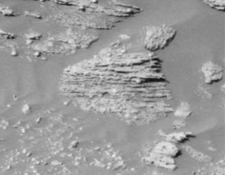
Scientists are excited to see new details of layered rocks in Opportunity Ledge. In previous panoramic camera images, geologists saw that some rocks in the outcrop had thin layers, and images sent to Earth on sol 17 (Feb. 10, 2004) now show that the thin layers are not always parallel to each other like lines on notebook paper. Instead, if you look closely at this image from an angle, you will notice that the lines converge and diverge at low angles. These unparallel lines give unparalleled clues that some "moving current" such as volcanic flow, wind, or water formed these rocks. These layers with converging and diverging lines are a significant discovery for scientists who are on route to rigorously test the water hypothesis. The main task for both rovers in coming weeks and months is to explore the areas around their landing sites for evidence in rocks and soils about whether those areas ever had environments that were watery and possibly suitable for sustaining life.
This is a cropped image taken by Opportunity's panoramic camera on sol 16 (Feb. 9, 2004).
Background Info:
JPL, a division of the California Institute of Technology in Pasadena, manages the Mars Exploration Rover project for NASA's Office of Space Science, Washington, D.C.
Cataloging Keywords:
| Name | Value | Additional Values |
|---|---|---|
| Target | Mars | |
| System | ||
| Target Type | Planet | |
| Mission | Mars Exploration Rover (MER) | Mars Global Surveyor (MGS) |
| Instrument Host | Mars Global Surveyor | Opportunity (MER-B) |
| Host Type | Orbiter | Rover |
| Instrument | Panoramic Camera (Pancam) | |
| Detector | ||
| Extra Keywords | Grayscale, Volcano, Water | |
| Acquisition Date | ||
| Release Date | 2004-02-11 | |
| Date in Caption | 2004-02-09 | 2004-02-10 |
| Image Credit | NASA/JPL/Cornell | |
| Source | photojournal.jpl.nasa.gov/catalog/PIA05256 | |
| Identifier | PIA05256 | |
