skip to navigation
|
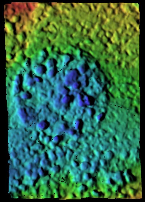
Map of Moessbauer Placement
- Click the image above for a larger view
- Full-Res JPEG (723 x 1005) (95.8 kB)
- Full-Res TIFF (723 x 1005) (2.1 MB)
Caption:
This elevation map of a soil target called "Peak" was created from images taken by the microscopic imager located on the Mars Exploration Rover Spirit's instrument deployment device or "arm." The image reveals the various high and low points of this spot of soil after the Moessbauer spectrometer, another instrument on the rover's arm, was gently placed down on it. The blue areas are farthest away from the instrument; the red areas are closest. The variation in distance between blue and red areas is only 2 millimeters, or .08 of an inch. The images were acquired on sol 39 (February 11, 2004).
Cataloging Keywords:
| Name | Value | Additional Values |
|---|---|---|
| Target | Mars | |
| System | ||
| Target Type | Planet | |
| Mission | Mars Exploration Rover (MER) | |
| Instrument Host | Spirit (MER-A) | |
| Host Type | Rover | |
| Instrument | Microscopic Imager (MI) | Moessbauer Spectrometer (MB) |
| Detector | ||
| Extra Keywords | Color, Map | |
| Acquisition Date | ||
| Release Date | 2004-02-17 | |
| Date in Caption | 2004-02-11 | |
| Image Credit | NASA/JPL/USGS | |
| Source | photojournal.jpl.nasa.gov/catalog/PIA05303 | |
| Identifier | PIA05303 | |