The Road Less Traveled
Caption:
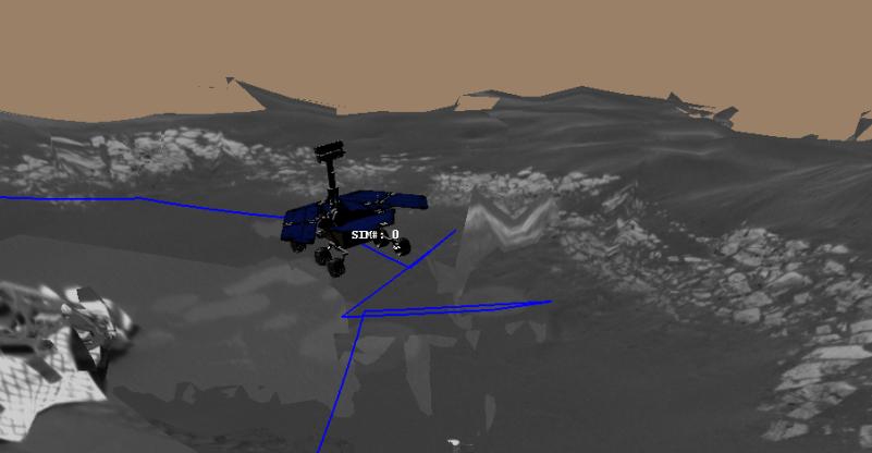
This image is a screenshot from a computer-generated animation showing the path the Mars Exploration Rover Opportunity traveled between the 16th and 21st days, or sols, of its mission. On sol 16, the rover followed a "V-shaped" route, driving backwards 2.5 meters (8.2 feet), turning in place 49 degrees counterclockwise, driving forward by 1 meter (3.3 feet), then driving forward again another 0.6 meters (2 feet). On sol 17, the rover traversed a "U-shaped" path, driving backwards 1.3 meters (4.3 feet), turning in place 90 degrees counterclockwise, driving forward 2.9 meters (9.5 feet), turning in place 90 degrees clockwise, driving forward 0.6 meters (2 feet), then finally driving forward again 0.5 meters (1.6 feet). On sol 19, the rover took another "V-shaped" journey, driving south backwards for approximately 1.9 meters (6.2 feet), turning in place to face the west-northwest rock target Zugspitze, then driving forward 2.5 meters (8.2 feet). On sol 21, the rover backed up 1.4 meters (4.6 meters), turned to the southwest, then via a series of arc turns, arrived at its trench location. Once there, the rover rotated 180 degrees to face 10 degrees to the west of north, then drove a short 0.5-meter-arc (1.6-foot-arc) forward. The drive ended with the rover facing approximately north, ready to dig a hole in the martian surface. Data from the rover's onboard sensors were used to make this animation.
Cataloging Keywords:
| Name |
Value |
Additional Values |
| Target |
Mars |
|
| System |
|
|
| Target Type |
Planet |
|
| Mission |
Mars Exploration Rover (MER) |
|
| Instrument Host |
Opportunity (MER-B) |
|
| Host Type |
Rover |
|
| Instrument |
|
|
| Detector |
|
|
| Extra Keywords |
Color, Rotation |
| Acquisition Date |
|
| Release Date |
2004-02-17 |
| Date in Caption |
|
|
| Image Credit |
NASA/JPL |
| Source |
photojournal.jpl.nasa.gov/catalog/PIA05310 |
| Identifier |
PIA05310 |