A Trail of Salts
Caption:
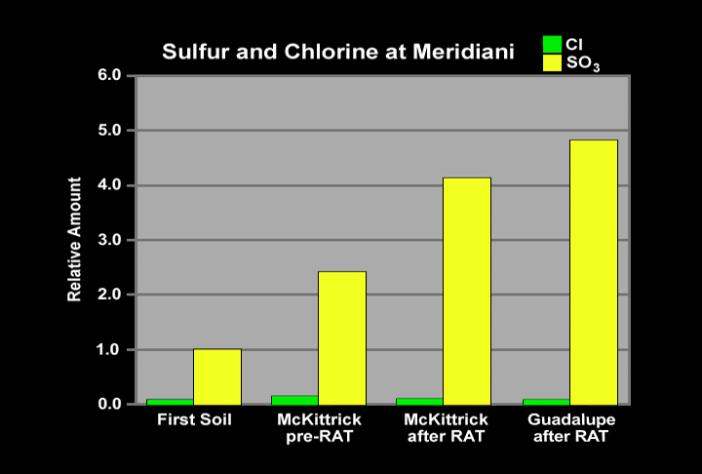
This graph shows the relative abundances of sulfur (in the form of sulfur tri-oxide) and chlorine at three Meridiani Planum sites: soil measured in the small crater where Opportunity landed; the rock dubbed "McKittrick" in the outcrop lining the inner edge of the crater; and the rock nicknamed "Guadalupe," also in the outcrop. The "McKittrick" data shown here were taken both before and after the rover finished grinding the rock with its rock abrasion tool to expose fresh rock underneath. The "Guadalupe" data were taken after the rover grounded the rock. After grinding both rocks, the sulfur abundance rose to high levels, nearly five times higher than that of the soil. This very high sulfur concentration reflects the heavy presence of sulfate salts (approximately 30 percent by weight) in the rocks. Chloride and bromide salts are also indicated. Such high levels of salts strongly suggest the rocks contain evaporite deposits, which form when water evaporates or ice sublimes into the atmosphere.
Cataloging Keywords:
| Name |
Value |
Additional Values |
| Target |
Mars |
|
| System |
|
|
| Target Type |
Planet |
|
| Mission |
Mars Exploration Rover (MER) |
Mars Science Laboratory (MSL) |
| Instrument Host |
Opportunity (MER-B) |
Curiosity Rover |
| Host Type |
Rover |
|
| Instrument |
Alpha Particle X-Ray Spectrometer (APXS) |
Rock Abrasion Tool (RAT) |
| Detector |
|
|
| Extra Keywords |
Atmosphere, Color, Crater, Water |
| Acquisition Date |
|
| Release Date |
2004-03-02 |
| Date in Caption |
|
|
| Image Credit |
NASA/JPL/Max Planck Institute |
| Source |
photojournal.jpl.nasa.gov/catalog/PIA05483 |
| Identifier |
PIA05483 |