skip to navigation

|
What Lies Ahead
- Click the image above for a larger view
- Full-Res JPEG (1197 x 896) (103.6 kB)
- Full-Res TIFF (1197 x 896) (1.8 MB)
Caption:
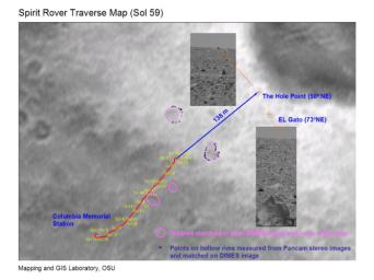
This map shows the path the Mars Exploration Rover Spirit will travel toward its future target, the large crater dubbed "Bonneville." The red line indicates Spirit's travels up to the 59th martian day, or sol, of its journey, and the blue line, the route it will follow. Engineers pinpointed the rover's exact location by comparing images taken by the panoramic camera on the rover (inset panels) to those acquired during descent by the descent image motion estimation system camera (underlying map).
Cataloging Keywords:
| Name | Value | Additional Values |
|---|---|---|
| Target | Mars | |
| System | ||
| Target Type | Planet | |
| Mission | Mars Exploration Rover (MER) | |
| Instrument Host | Spirit (MER-A) | |
| Host Type | Rover | |
| Instrument | Descent Image Motion Estimation System (DIMES) | Panoramic Camera (Pancam) |
| Detector | ||
| Extra Keywords | Color, Crater, Map | |
| Acquisition Date | ||
| Release Date | 2004-03-06 | |
| Date in Caption | ||
| Image Credit | NASA/JPL/Cornell/Ohio State University | |
| Source | photojournal.jpl.nasa.gov/catalog/PIA05506 | |
| Identifier | PIA05506 | |
