skip to navigation
|
Spirit’s Extended-Mission Destination
- Click the image above for a larger view
- Full-Res JPEG (622 x 374) (47.3 kB)
- Full-Res TIFF (622 x 374) (405.6 kB)
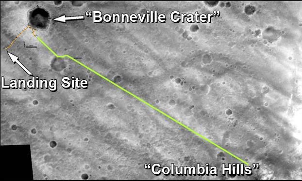
Caption:
The drive route planned for NASA's Mars Exploration Rover Spirit during its extended mission is represented by the green line in this traverse map. The gold line traces the path Spirit drove during its prime mission of 90 sols.
One objective for the rover's extended mission is to continue eastward to reach the high ground named "Columbia Hills," still about 2 kilometers (1.2 miles) away at the beginning of the extended mission.
The base image for this map was taken from orbit by NASA's Mars Global Surveyor. The entire area is within Gusev Crater.
Cataloging Keywords:
| Name | Value | Additional Values |
|---|---|---|
| Target | Mars | |
| System | ||
| Target Type | Planet | |
| Mission | Mars Global Surveyor (MGS) | Mars Exploration Rover (MER) |
| Instrument Host | Mars Global Surveyor | Spirit (MER-A) |
| Host Type | Orbiter | Rover |
| Instrument | Mars Orbiter Camera (MOC) | |
| Detector | ||
| Extra Keywords | Color, Crater, Map | |
| Acquisition Date | ||
| Release Date | 2004-04-08 | |
| Date in Caption | ||
| Image Credit | NASA/JPL/MSSS/New Mexico Museum of Natural History | |
| Source | photojournal.jpl.nasa.gov/catalog/PIA05720 | |
| Identifier | PIA05720 | |