|
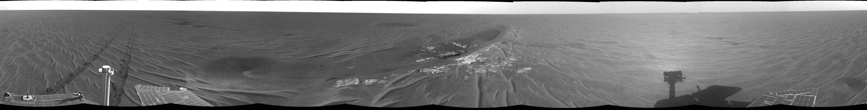
At the Edge of ‘Anatolia’
- Click the image above for a larger view
- Full-Res JPEG (7688 x 979) (870.1 kB)
- Full-Res TIFF (7688 x 979) (6.0 MB)
Caption:
Click on the image for At the Edge of 'Anatolia' (QTVR)
This 360-degree image mosaic was constructed from a sequence of images taken by the navigation camera onboard the Mars Exploration Rover Opportunity. The mosaic was created from 10 images.
The images were acquired on the 72nd martian day, or sol, of Opportunity's mission to Meridiani Planum. The camera acquired the images at approximately 16:00 local solar time, or just before midnight Pacific Daylight Time on April 6, 2004.
The image was taken from the rover's current position along the edge of the large trough dubbed "Anatolia," located some 150 meters (492 feet) away from "Eagle Crater." Scientists will likely investigate the rocks contained here in coming sols. They are also interested in the area's soil, which -- as evident from the rover's shallow tracks -- appears stronger than that of Eagle Crater. The dark crater behind the trough can be seen from orbit.
Anatolia was named after the Anatolian fault system in Turkey.
Cataloging Keywords:
| Name | Value | Additional Values |
|---|---|---|
| Target | Mars | |
| System | ||
| Target Type | Planet | |
| Mission | Mars Exploration Rover (MER) | |
| Instrument Host | Opportunity (MER-B) | |
| Host Type | Rover | |
| Instrument | Navigation Camera (Navcam) | |
| Detector | ||
| Extra Keywords | Crater, Grayscale | |
| Acquisition Date | ||
| Release Date | 2004-04-08 | |
| Date in Caption | 2004-04-06 | |
| Image Credit | NASA/JPL | |
| Source | photojournal.jpl.nasa.gov/catalog/PIA05727 | |
| Identifier | PIA05727 | |