|
Spirit’s Express Route to ‘Columbia Hills’
- Click the image above for a larger view
- Full-Res JPEG (720 x 540) (86.3 kB)
- Full-Res TIFF (720 x 540) (1.1 MB)
Caption:
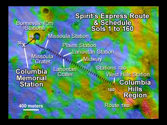
This map illustrates the Mars Exploration Rover Spirit's position as of sol 112 (April 26, 2004), near the crater called "Missoula." Like a train on a tight schedule, Spirit will make regular stops along the way to its ultimate destination, the "Columbia Hills." At each stop, or "station," the rover will briefly analyze the area's rocks and soils. Each tick mark on the rover's route represents one sol's worth of travel, or about 60 to 70 meters (200 to 230 feet). Rover planners estimate that Spirit will reach the hills around mid-June. Presently, the rover is stopped at a site called "Plains Station."
The color thermal data show how well different surface features hold onto heat. Red indicates a higher thermal inertia associated with rocky terrain (cooler in the day, warmer at night); blue indicates a lower thermal inertia associated with smaller particles and fewer rocks (warmer at night, cooler in the day). During its traverse, Spirit will document the causes of these thermal variations.
The map comprises data from the camera on NASA's Mars Global Surveyor orbiter and the thermal emission imaging system on NASA's Mars Odyssey orbiter.
Cataloging Keywords:
| Name | Value | Additional Values |
|---|---|---|
| Target | Mars | |
| System | ||
| Target Type | Planet | |
| Mission | Mars Global Surveyor (MGS) | 2001 Mars Odyssey, Mars Exploration Rover (MER) |
| Instrument Host | Mars Global Surveyor | Mars Odyssey, Spirit (MER-A) |
| Host Type | Orbiter | Rover |
| Instrument | Mars Orbiter Camera (MOC) | |
| Detector | ||
| Extra Keywords | Color, Crater, Map, Thermal | |
| Acquisition Date | ||
| Release Date | 2004-05-06 | |
| Date in Caption | 2004-04-26 | |
| Image Credit | NASA/JPL/ASU/MSSS/Ames | |
| Source | photojournal.jpl.nasa.gov/catalog/PIA05873 | |
| Identifier | PIA05873 | |