West Arabian Yardangs
Caption:
17 September 2004
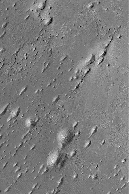
The upper crust of Mars consists of layered bedrock. The terrain located between large impact craters is layered. In some regions, some of these layers have been exposed by erosion. This Mars Global Surveyor (MGS) Mars Orbiter Camera (MOC) image shows rounded and streamlined hills produced by wind erosion. In this case, the dominant, erosive winds blew from the upper right (northeast) toward lower left (southwest). The presence of these erosional forms,
yardangs
, indicates that the material being eroded contains some amount of sand-sized grains that are easily mobilized by wind. These particular yardangs are located in western Arabia Terra, northwest of the Sinus Meridiani region where the Mars Exploration Rover, Opportunity, has examined ancient sedimentary rocks. These landforms are located near 9.4°N, 6.5°W. The image covers an area approximately 3 km (1.9 mi) across and is illuminated by sunlight from the left.
Cataloging Keywords:
| Name |
Value |
Additional Values |
| Target |
Mars |
|
| System |
|
|
| Target Type |
Planet |
|
| Mission |
Mars Global Surveyor (MGS) |
Mars Exploration Rover (MER) |
| Instrument Host |
Mars Global Surveyor |
Opportunity (MER-B) |
| Host Type |
Orbiter |
Rover |
| Instrument |
Mars Orbiter Camera (MOC) |
|
| Detector |
|
|
| Extra Keywords |
Crater, Grayscale, Impact |
| Acquisition Date |
|
| Release Date |
2004-09-17 |
| Date in Caption |
2004-09-17 |
|
| Image Credit |
NASA/JPL/Malin Space Science Systems |
| Source |
photojournal.jpl.nasa.gov/catalog/PIA05947 |
| Identifier |
PIA05947 |
