skip to navigation

|
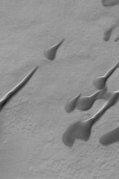
Martian Dunes
- Click the image above for a larger view
- Full-Res JPEG (831 x 1247) (181.6 kB)
- Full-Res TIFF (831 x 1247) (1.0 MB)
Caption:
22 September 2004
This Mars Global Surveyor (MGS) Mars Orbiter Camera (MOC) image shows dark, windblown sand dunes in a south mid-latitude crater near 49.5°S, 352.9°W. The elongated portions of these dunes indicate that, for some period of time during their development, there were two dominant wind directions involved. The most dominant of these winds blew from the south-southeast (lower right), as indicated by the presence of the steepest dune slopes on their northwest (facing upper left) sides. This image covers an area approximately 3 km (1.9 mi) across and is illuminated by sunlight from the upper left.
Cataloging Keywords:
| Name | Value | Additional Values |
|---|---|---|
| Target | Mars | |
| System | ||
| Target Type | Planet | |
| Mission | Mars Global Surveyor (MGS) | |
| Instrument Host | Mars Global Surveyor | |
| Host Type | Orbiter | |
| Instrument | Mars Orbiter Camera (MOC) | |
| Detector | ||
| Extra Keywords | Crater, Dune, Grayscale | |
| Acquisition Date | ||
| Release Date | 2004-09-22 | |
| Date in Caption | 2004-09-22 | |
| Image Credit | NASA/JPL/Malin Space Science Systems | |
| Source | photojournal.jpl.nasa.gov/catalog/PIA05952 | |
| Identifier | PIA05952 | |
