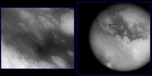
Huygen’s Landing Site
Caption:
Shown here are two images of the expected landing site of Cassini's Huygen's probe (latitude 10.6°S, longitude 191°W). At right is a wide-angle image showing most of Titan's disc, with a scale of 10 kilometers (6.2 miles) per pixel. At left is a narrow-angle image of the landing site at a scale of 0.83 kilometers (.5 miles) per pixel (location shown by black box at right). North is tilted about 45 degrees from the top of both images. The surface has bright and dark markings with a streamlined pattern consistent with motion from a fluid, such as the atmosphere, moving from west to east (upper left to lower right). The image at left is 400 kilometers (249 miles) wide. Both images were taken by Cassini's imaging science subsystem through near-infrared filters.
Background Info:
The Cassini-Huygens mission is a cooperative project of NASA, the European Space Agency and the Italian Space Agency. The Jet Propulsion Laboratory, a division of the California Institute of Technology in Pasadena, manages the Cassini-Huygens mission for NASA's Office of Space Science, Washington, D.C. The Cassini orbiter and its two onboard cameras, were designed, developed and assembled at JPL. The imaging team is based at the Space Science Institute, Boulder, Colo.
For more information, about the Cassini-Huygens mission visit,
http://saturn.jpl.nasa.gov
and the Cassini imaging team home page,
http://ciclops.org
.
Cataloging Keywords:
| Name |
Value |
Additional Values |
| Target |
Titan |
|
| System |
Saturn |
|
| Target Type |
Satellite |
|
| Mission |
Cassini-Huygens |
|
| Instrument Host |
Cassini Orbiter |
|
| Host Type |
Orbiter |
|
| Instrument |
Imaging Science Subsystem (ISS) |
|
| Detector |
|
Narrow Angle Camera, Wide Angle Camera |
| Extra Keywords |
Atmosphere, Color, Infrared, Visual |
| Acquisition Date |
|
| Release Date |
2004-10-27 |
| Date in Caption |
|
|
| Image Credit |
NASA/JPL/Space Science Institute |
| Source |
photojournal.jpl.nasa.gov/catalog/PIA06136 |
| Identifier |
PIA06136 |

 Planetary Data System
