|
Deep Color
- Click the image above for a larger view
- Full-Res JPEG (1020 x 1020) (224.2 kB)
- Full-Res TIFF (1020 x 1020) (3.1 MB)
Caption:
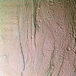
This false-color, close-up look at Saturn's moon Enceladus yields new insight into the different processes that have shaped the moon's icy surface.
Extending through the center of this image is a system of rifts 3 kilometers wide (2 mile) and lanes of grooved terrain 20 kilometers wide (12 mile), which separate two distinct geological provinces. To the right of the boundary is older, cratered terrain - a region peppered with craters ranging from 10 kilometers (6 miles) in diameter, down craters near the limit of resolution. The region is believed to be old because it has accumulated a relatively high density of impact craters over time and the topography is soft and muted, suggesting that it is covered by a layer of particulate materials. The cratered terrain is cut crosswise by numerous faults and fractures ranging in width from hundreds of meters to a few kilometers.
On the left side of the scene are grooved, icy plains. This broad, relatively flat region is scored by an extensive band of parallel grooves that appear to subdivide the surface into narrow lanes approximately 1 kilometer or half a mile wide. The low abundance of impact craters and crisp relief on topographic features here imply that this region is geologically much younger than the cratered terrain at the right.
This view is a composite of images taken using filters sensitive to ultraviolet (centered at 338 nanometers), green (centered at 568 nanometers), and near-infrared (centered at 930 nanometers) light, and has been processed to accentuate subtle color differences.
The uppermost surface of these terrains has a relatively uniform pinkish cast in this picture, suggesting that it is covered with materials of homogeneous composition and grain size. However, many of the fractures reveal a distinctly different color (represented by greenish tones in this false-color image) than the typical surface materials in this region. The fractures seem to penetrate down to a material that is texturally or compositionally different than most surface materials. One possibility is that the walls of the fractures expose outcrops of solid ice or ice with different grain-sizes compared to powdery surface materials that mantle flat-lying surfaces. It is also possible that the color identifies some compositional difference between buried ice and ice at the surface.
The scene is located on the side of Enceladus that faces away from Saturn. The images were obtained with the Cassini spacecraft narrow-angle camera when the spacecraft was at a distance of approximately 25,700 kilometers (15,969 miles) from Enceladus and at a Sun-Enceladus-spacecraft, or phase, angle of 46 degrees. Resolution in the image is about 150 meters (490 feet) per pixel.
Background Info:
The Cassini-Huygens mission is a cooperative project of NASA, the European Space Agency and the Italian Space Agency. The Jet Propulsion Laboratory, a division of the California Institute of Technology in Pasadena, manages the mission for NASA's Science Mission Directorate, Washington, D.C. The Cassini orbiter and its two onboard cameras were designed, developed and assembled at JPL. The imaging team is based at the Space Science Institute, Boulder, Colo.
For more information about the Cassini-Huygens mission, visit http://saturn.jpl.nasa.gov and the Cassini imaging team home page, http://ciclops.org .
Cataloging Keywords:
| Name | Value | Additional Values |
|---|---|---|
| Target | Enceladus | Saturn |
| System | Saturn | |
| Target Type | Satellite | Planet |
| Mission | Cassini-Huygens | |
| Instrument Host | Cassini Orbiter | |
| Host Type | Orbiter | |
| Instrument | Imaging Science Subsystem (ISS) | |
| Detector | Narrow Angle Camera | |
| Extra Keywords | Color, Crater, Impact, Infrared, Ultraviolet, Visual | |
| Acquisition Date | ||
| Release Date | 2005-03-16 | |
| Date in Caption | ||
| Image Credit | NASA/JPL/Space Science Institute | |
| Source | photojournal.jpl.nasa.gov/catalog/PIA06209 | |
| Identifier | PIA06209 | |
