|
Closer to Enceladus
- Click the image above for a larger view
- Full-Res JPEG (1262 x 982) (130.5 kB)
- Full-Res TIFF (1262 x 982) (3.7 MB)
Caption:
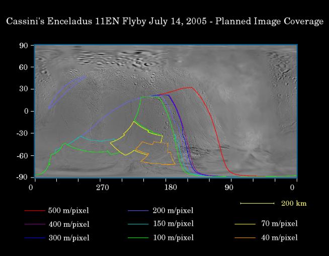
This map of the surface of Enceladus illustrates the regions that will be imaged by NASA's Cassini spacecraft during its planned very close flyby on July 14, 2005. At closest approach, the spacecraft is expected to pass approximately 175 kilometers (108 miles) above the moon's surface. This is less than half the distance of Cassini's previous encounter with Enceladus (505 kilometers, 314 miles across), in March of this year.
The colored lines delineate the regions that will be imaged at the range of resolutions listed in the legend below.
An important scientific goal of this close flyby, during which Cassini will view the moon's previously unseen south pole, will be to search for evidence of geologically recent tectonic or volcanic activity.
During the March 2005 Enceladus flyby, Cassini revealed fractures at southern latitudes, which have intriguing spectral differences from the surrounding terrain (see PIA06208). This possibly indicates the presence of coarse-grained ice on the walls of geologically recent, large cracks in the surface.
The map was made from images obtained by both the Cassini and Voyager spacecrafts.
Background Info:
The Cassini-Huygens mission is a cooperative project of NASA, the European Space Agency and the Italian Space Agency. The Jet Propulsion Laboratory, a division of the California Institute of Technology in Pasadena, manages the mission for NASA's Science Mission Directorate, Washington, D.C. The Cassini orbiter and its two onboard cameras were designed, developed and assembled at JPL. The imaging team is based at the Space Science Institute, Boulder, Colo.
For more information about the Cassini-Huygens mission visit http://saturn.jpl.nasa.gov . For additional images visit the Cassini imaging team homepage http://ciclops.org .
Cataloging Keywords:
| Name | Value | Additional Values |
|---|---|---|
| Target | Enceladus | |
| System | Saturn | |
| Target Type | Satellite | |
| Mission | Cassini-Huygens | Voyager |
| Instrument Host | Cassini Orbiter | |
| Host Type | Orbiter | Flyby Spacecraft |
| Instrument | Imaging Science Subsystem (ISS) | |
| Detector | ||
| Extra Keywords | Color, Map, Volcano | |
| Acquisition Date | ||
| Release Date | 2005-07-15 | |
| Date in Caption | 2005-07-14 | |
| Image Credit | NASA/JPL/Space Science Institute | |
| Source | photojournal.jpl.nasa.gov/catalog/PIA06246 | |
| Identifier | PIA06246 | |