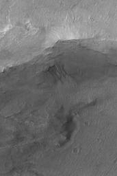
Gullied Trough Wall
Caption:
13 June 2004
This Mars Global Surveyor (MGS) Mars Orbiter Camera (MOC) image shows gullies emergent from beneath erosion-resistant rock layers in a trough south of Atlantis Chaos near 38.9°S, 176.3°W. Gullies such as these are fairly common in depressions at south middle latitudes. Tens of thousands of gullies have been identified in MGS MOC and Mars Odyssey Thermal Emission Imaging System (THEMIS) images. Whether they formed by running liquid water remains a controversial issue. Banked channels, like some shown here, are one form of evidence cited to indicate that a fluid with the properties of liquid water may have been involved. This image covers an area about 3 km (1.9 mi) across. The scene is illuminated by sunlight from the upper left.
Cataloging Keywords:
| Name |
Value |
Additional Values |
| Target |
Mars |
|
| System |
|
|
| Target Type |
Planet |
|
| Mission |
Mars Global Surveyor (MGS) |
2001 Mars Odyssey |
| Instrument Host |
Mars Global Surveyor |
Mars Odyssey |
| Host Type |
Orbiter |
|
| Instrument |
Mars Orbiter Camera (MOC) |
|
| Detector |
|
|
| Extra Keywords |
Grayscale, Thermal, Water |
| Acquisition Date |
|
| Release Date |
2004-06-13 |
| Date in Caption |
2004-06-13 |
|
| Image Credit |
NASA/JPL/Malin Space Science Systems |
| Source |
photojournal.jpl.nasa.gov/catalog/PIA06303 |
| Identifier |
PIA06303 |

