|
Spirit Traverse Map
- Click the image above for a larger view
- Full-Res JPEG (1183 x 638) (102.9 kB)
- Full-Res TIFF (1183 x 638) (2.3 MB)
Caption:
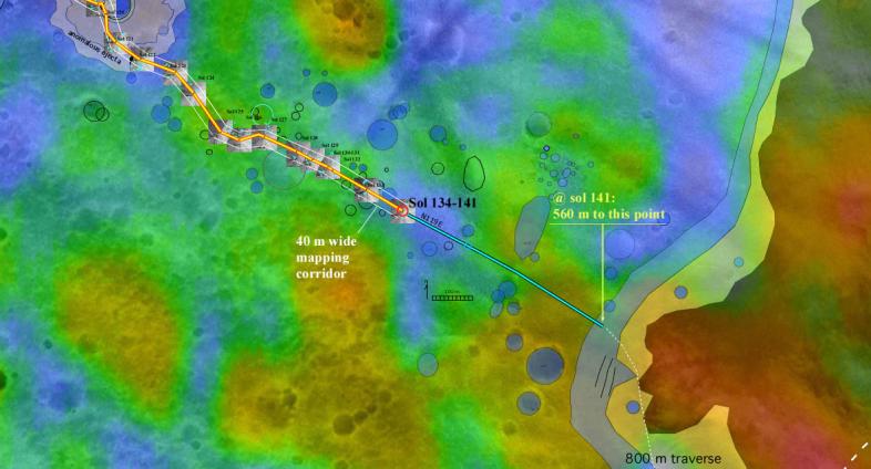
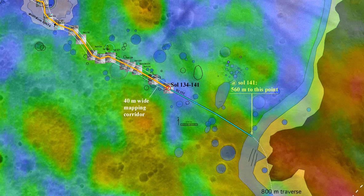
The red dot labeled "Sol 134-141" in this map illustrates when and where NASA's Mars Exploration Rover Spirit acquired the "Santa Anita Panorama." Scientists consider this area, located roughly three-fourths of the way between "Bonneville Crater" and the base of the "Columbia Hills," a treasure trove that may be studied for decades to come. The panorama is one of four 360-degree full panoramas the rover has acquired during its mission.
The color thermal inertia data show how well different surface features hold onto heat. Red indicates a high thermal inertia associated with rocky terrain (regions that take longer to warm up and cool down); blue indicates a lower thermal inertia associated with smaller particles and fewer rocks (areas that warm up and cool off quickly). The map comprises background images from the camera on NASA's Mars Global Surveyor orbiter and data from the thermal emission spectrometer on NASA's Mars Odyssey orbiter.
Cataloging Keywords:
| Name | Value | Additional Values |
|---|---|---|
| Target | Mars | |
| System | ||
| Target Type | Planet | |
| Mission | 2001 Mars Odyssey | Mars Exploration Rover (MER), Mars Global Surveyor (MGS) |
| Instrument Host | Mars Odyssey | Mars Global Surveyor, Spirit (MER-A) |
| Host Type | Orbiter | Rover |
| Instrument | Mars Orbiter Camera (MOC) | Thermal Emission Spectrometer (TES) |
| Detector | ||
| Extra Keywords | Color, Crater, Map, Thermal | |
| Acquisition Date | ||
| Release Date | 2004-07-16 | |
| Date in Caption | ||
| Image Credit | NASA/JPL/MSSS/ASU/Ames/New Mexico Museum of Natural History and Science | |
| Source | photojournal.jpl.nasa.gov/catalog/PIA06688 | |
| Identifier | PIA06688 | |