
|
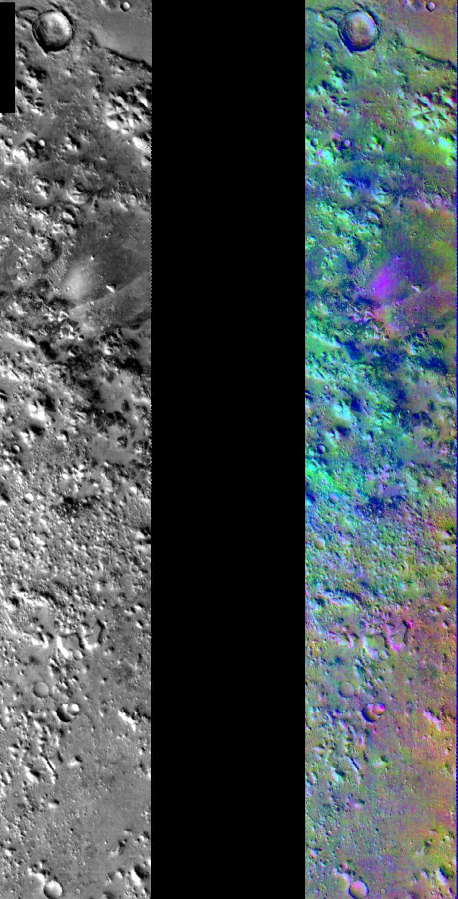
Decorrelation Stretch Near Cerberus Fossae
- Click the image above for a larger view
- Full-Res JPEG (927 x 1819) (260.1 kB)
- Full-Res TIFF (927 x 1819) (3.3 MB)
Caption:
Released July 25, 2004On this image you can see two infrared frames of the same area on Mars. One of the images (in black and white) represents a single wavelength or band of the THEMIS IR instrument, while the other image (in false color) represents 3 different bands. The image with the various colors was created with a technique called Decorrelation Stretch (DCS). In this technique individual bands of the THEMIS IR instrument are stretched to better show compositional variations throughout the whole range. After the bands are stretched they are overlayed on one another and colors are assigned to each band. This makes up the colors in the image.
As you can see, there is a difference in what is noticable in the single band IR image versus the false-colored one. On the color image the pink/magenta colors usually represent basaltic content, cyan often indicates the presence of water ice clouds, while green can represent dust.
The bright purple and pink colors associated with the valley are due to basalt. There may be a thin veneer of dust present in the region (it was a dark colored region during the Viking mission in the 1970's) through which the basaltic material pokes out along the edges of the valley and the nearby knobby terrain.
Image information: IR instrument. Latitude 10.7, Longitude 163 East (197 West). 100 meter/pixel resolution.
Note: this THEMIS visual image has not been radiometrically nor geometrically calibrated for this preliminary release. An empirical correction has been performed to remove instrumental effects. A linear shift has been applied in the cross-track and down-track direction to approximate spacecraft and planetary motion. Fully calibrated and geometrically projected images will be released through the Planetary Data System in accordance with Project policies at a later time.
Background Info:
NASA's Jet Propulsion Laboratory manages the 2001 Mars Odyssey mission for NASA's Office of Space Science, Washington, D.C. The Thermal Emission Imaging System (THEMIS) was developed by Arizona State University, Tempe, in collaboration with Raytheon Santa Barbara Remote Sensing. The THEMIS investigation is led by Dr. Philip Christensen at Arizona State University. Lockheed Martin Astronautics, Denver, is the prime contractor for the Odyssey project, and developed and built the orbiter. Mission operations are conducted jointly from Lockheed Martin and from JPL, a division of the California Institute of Technology in Pasadena.
Cataloging Keywords:
| Name | Value | Additional Values |
|---|---|---|
| Target | Mars | |
| System | ||
| Target Type | Planet | |
| Mission | 2001 Mars Odyssey | Viking |
| Instrument Host | Mars Odyssey | |
| Host Type | Orbiter | |
| Instrument | Thermal Emission Imaging System (THEMIS) | |
| Detector | ||
| Extra Keywords | Color, Dust, Infrared, Thermal, Water | |
| Acquisition Date | ||
| Release Date | 2004-07-27 | |
| Date in Caption | ||
| Image Credit | NASA/JPL/Arizona State University | |
| Source | photojournal.jpl.nasa.gov/catalog/PIA06725 | |
| Identifier | PIA06725 | |