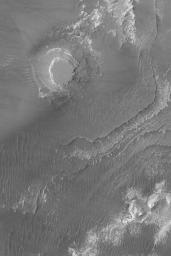
Mesa in Aureum Chaos
Caption:
2 August 2004
This Mars Global Surveyor (MGS) Mars Orbiter Camera (MOC) image shows a circular mesa and layered materials that are partially-exposed from beneath a thick, dark mantle in the Aureum Chaos region of Mars. The features are part of a much larger circular form (bigger than the image shown here) that marks the location of a crater that was filled with light-toned sedimentary rock, buried, and then later re-exposed when the upper crust of Mars broke apart in this region to form buttes and mesas of "chaotic terrain." The circular mesa in this image might also be the location of a formerly filled and buried crater. This image is located near 4.0°S, 26.9°W. It covers an area about 3 km (1.9 mi) across; sunlight illuminates the scene from the left/upper left.
Cataloging Keywords:
| Name |
Value |
Additional Values |
| Target |
Mars |
|
| System |
|
|
| Target Type |
Planet |
|
| Mission |
Mars Global Surveyor (MGS) |
|
| Instrument Host |
Mars Global Surveyor |
|
| Host Type |
Orbiter |
|
| Instrument |
Mars Orbiter Camera (MOC) |
|
| Detector |
|
|
| Extra Keywords |
Crater, Grayscale |
| Acquisition Date |
|
| Release Date |
2004-08-02 |
| Date in Caption |
2004-08-02 |
|
| Image Credit |
NASA/JPL/Malin Space Science Systems |
| Source |
photojournal.jpl.nasa.gov/catalog/PIA06745 |
| Identifier |
PIA06745 |

