|
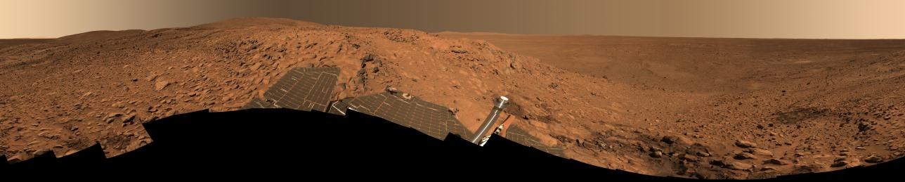
‘Cahokia’ Panorama
- Click the image above for a larger view
- Full-Res JPEG (22348 x 4487) (8.8 MB)
- Full-Res TIFF (22348 x 4487) (183.7 MB)
Caption:
Click on the image for 'Cahokia' Panorama (QTVR)
This stunning image mosaic of the "Columbia Hills" is the first 360-degree panorama taken since the Mars Exploration Rover Spirit arrived at the hills over a month ago. The rover has been busy studying the rocks here, which show evidence of past alteration by water. The dark patch of soil to the right is the spot where Spirit stopped for engineering work on its right front wheel. Spirit's tracks can be followed from there all the way back to "Bonneville Crater" and the original landing site, more than 3 kilometers (1.86 miles) away.
This approximate true-color image, nicknamed the "Cahokia panorama" after the Native American archaeological site near St. Louis, was acquired between sols 213 to 223 (Aug. 9 to 19, 2004). The panorama consists of 470 images acquired through six panoramic camera filters (750 to 480 nanometers). It took until the week of sol 237 (Sept. 2) to downlink all the data back to Earth. Several more weeks of image processing and geometric mapping by team members at Jet Propulsion Laboratory, Pasadena, Calif., and Cornell University, Ithaca, N.Y., were required to stitch all the images together into this spectacular mosaic.
Cataloging Keywords:
| Name | Value | Additional Values |
|---|---|---|
| Target | Mars | |
| System | ||
| Target Type | Planet | |
| Mission | Mars Exploration Rover (MER) | |
| Instrument Host | Spirit (MER-A) | |
| Host Type | Rover | |
| Instrument | Panoramic Camera (Pancam) | |
| Detector | ||
| Extra Keywords | Color, Crater, Water | |
| Acquisition Date | ||
| Release Date | 2004-10-07 | |
| Date in Caption | ||
| Image Credit | NASA/JPL/Cornell | |
| Source | photojournal.jpl.nasa.gov/catalog/PIA06917 | |
| Identifier | PIA06917 | |