
|
Behold Titan’s Surface
- Click the image above for a larger view
- Full-Res JPEG (618 x 296) (19.8 kB)
- Full-Res TIFF (618 x 296) (182.5 kB)
Caption:
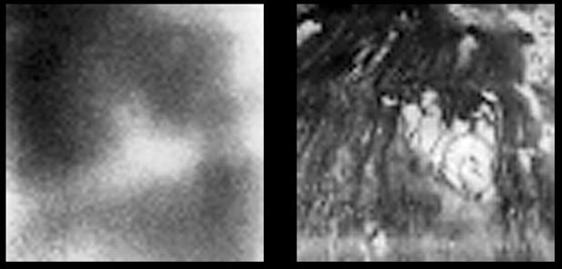
These images show the surface of Titan at two different infrared wavelengths. They were captured by the visual and infrared mapping spectrometer onboard Cassini as the spacecraft flew by at an altitude of 1200 kilometers (745 miles) -- Cassini's closest approach yet to the hazy moon. The image on the left was taken at a wavelength of 1 micron and shows approximately what a digital camera might see. The image on the right, taken at a wavelength of 2 microns, is the most detailed picture to date of the Titan's surface. It reveals complex landforms with sharp boundaries, which scientists are eager to further study.
Background Info:
The Cassini-Huygens mission is a cooperative project of NASA, the European Space Agency and the Italian Space Agency. The Jet Propulsion Laboratory, a division of the California Institute of Technology in Pasadena, manages the Cassini-Huygens mission for NASA's Science Mission Directorate, Washington, D.C. The Cassini orbiter and its two onboard cameras were designed, developed and assembled at JPL. The visual and infrared mapping spectrometer team is based at the University of Arizona, Tucson.
For more information about the Cassini-Huygens mission visit, http://saturn.jpl.nasa.gov . For more information about the visual and infrared mapping spectrometer visit http://wwwvims.lpl.arizona.edu/ .
Cataloging Keywords:
| Name | Value | Additional Values |
|---|---|---|
| Target | Titan | |
| System | Saturn | |
| Target Type | Satellite | |
| Mission | Cassini-Huygens | |
| Instrument Host | Cassini Orbiter | |
| Host Type | Orbiter | |
| Instrument | Visual and Infrared Mapping Spectrometer (VIMS) | |
| Detector | ||
| Extra Keywords | Atmosphere, Grayscale, Haze, Infrared | |
| Acquisition Date | ||
| Release Date | 2004-10-27 | |
| Date in Caption | ||
| Image Credit | NASA/JPL/University of Arizona | |
| Source | photojournal.jpl.nasa.gov/catalog/PIA06982 | |
| Identifier | PIA06982 | |