|
Topography on Titan
- Click the image above for a larger view
- Full-Res JPEG (720 x 540) (39.7 kB)
- Full-Res TIFF (720 x 540) (154.4 kB)
Caption:
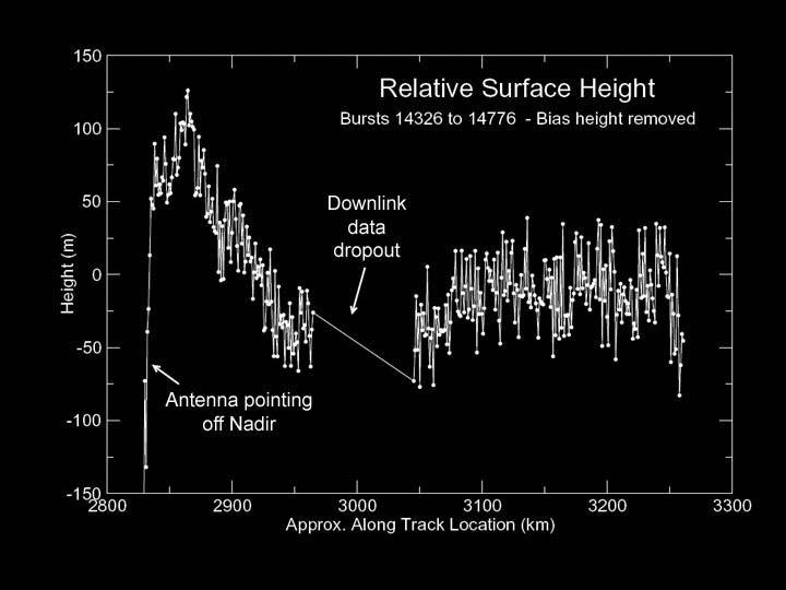
This graph, produced using preliminary altimetry data from Cassini's radar instrument, shows relative surface heights on Titan. The data were acquired on Oct. 26, 2004, during Cassini's first close encounter with Titan, at distances ranging from 5,000 to 10,000 kilometers (3,100 to 6,200 miles). The location observed is near latitude 25 degrees north, longitude 5 degrees west.
The data show a variation in height of only about 150 meters (490 feet) over the 400-kilometer-long (250-mile-long) track, indicating that in this region Titan is remarkably flat. Fine details in the data are likely to be noise, and not surface features. The area marked "downlink data dropout" was lost during transmission from the spacecraft to Earth but will be recovered by a later data replay.
Background Info:
The Cassini-Huygens mission is a cooperative project of NASA, the European Space Agency and the Italian Space Agency. The Jet Propulsion Laboratory, a division of the California Institute of Technology in Pasadena, manages the Cassini-Huygens mission for NASA's Science Mission Directorate, Washington, D.C. The Cassini orbiter and its two onboard cameras were designed, developed and assembled at JPL. The instrument team is based at NASA's Jet Propulsion Laboratory, Pasadena, Calif.
For the latest news about the Cassini-Huygens mission visit http://www.nasa.gov/cassini . For more information about the mission visit http://saturn.jpl.nasa.gov .
Cataloging Keywords:
| Name | Value | Additional Values |
|---|---|---|
| Target | Titan | |
| System | Saturn | |
| Target Type | Satellite | |
| Mission | Cassini-Huygens | |
| Instrument Host | Cassini Orbiter | |
| Host Type | Orbiter | |
| Instrument | Radar Mapper | |
| Detector | ||
| Extra Keywords | Grayscale, Radar | |
| Acquisition Date | ||
| Release Date | 2004-10-28 | |
| Date in Caption | 2004-10-26 | |
| Image Credit | NASA/JPL-Caltech/ASI | |
| Source | photojournal.jpl.nasa.gov/catalog/PIA06989 | |
| Identifier | PIA06989 | |