skip to navigation

|
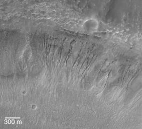
A Gullied Crater Wall
- Click the image above for a larger view
- Full-Res JPEG (1880 x 1701) (863.9 kB)
- Full-Res TIFF (1880 x 1701) (3.2 MB)
Caption:
23 November 2004
This Mars Global Surveyor (MGS) Mars Orbiter Camera (MOC) image shows a suite of southern middle-latitude gullies cut into the wall of an impact crater located near 32.1°S, 12.9°W. These gullies might indicate that groundwater seeped to the surface and ran down these slopes. Others have suggested that similar gullies on Mars might form by other processes, including melting of ground ice or snow, but this image does not provide any clues that would suggest either of these alternatives are better than the groundwater interpretation. The 300 meter scale bar is about 984 feet long. Sunlight illuminates the scene from the upper left.
Cataloging Keywords:
| Name | Value | Additional Values |
|---|---|---|
| Target | Mars | |
| System | ||
| Target Type | Planet | |
| Mission | Mars Global Surveyor (MGS) | |
| Instrument Host | Mars Global Surveyor | |
| Host Type | Orbiter | |
| Instrument | Mars Orbiter Camera (MOC) | |
| Detector | ||
| Extra Keywords | Crater, Grayscale, Impact, Water | |
| Acquisition Date | ||
| Release Date | 2004-11-23 | |
| Date in Caption | 2004-11-23 | |
| Image Credit | NASA/JPL/Malin Space Science Systems | |
| Source | photojournal.jpl.nasa.gov/catalog/PIA07067 | |
| Identifier | PIA07067 | |
