East Candor cPROTO
Caption:
30 November 2004
This Mars Global Surveyor (MGS) Mars Orbiter Camera (MOC) image was acquired using the cPROTO technique described on 27 September 2004 in "
cPROTO Views of Spirit's Rover Tracks and Athabasca Vallis Flood Features.
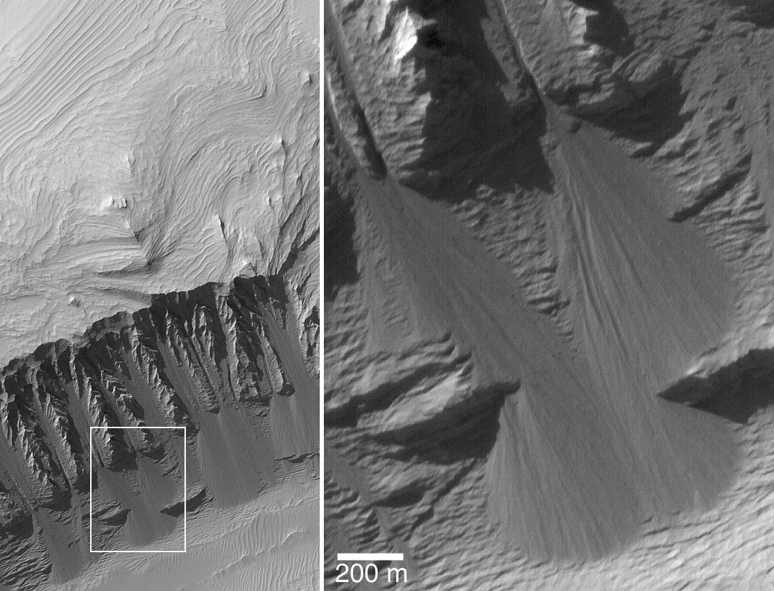
" In other words, the picture was obtained by MOC with a resolution that is better than 1 meter per pixel (better than 3 feet per pixel). On the left is a view of the entire cPROTO image; on the right is a magnified view of the features seen in the white box on the left. The 200 meter scale bar is about 219 yards long. This cPROTO image, obtained in August 2004, shows layered sedimentary rocks exposed in eastern Candor Chasma, part of the vast Valles Marineris trough system. On the steep slope in the lower half of the image (left), the rocks have been breaking down into fine-grained material that slides down the slope to create fan-shaped talus accumulations. In some cases, the movement of this dry debris has cut narrow, straight chutes into the slope. The sub-meter resolution of the cPROTO image reveals that there are no boulders in the talus, attesting to the extremely fine-grained and easily broken-up nature of these sedimentary rocks. The image is located near 7.3°S, 69.0°W. Sunlight illuminates the scene from the upper left.
Cataloging Keywords:
| Name |
Value |
Additional Values |
| Target |
Mars |
|
| System |
|
|
| Target Type |
Planet |
|
| Mission |
Mars Global Surveyor (MGS) |
Mariner, Mars Exploration Rover (MER) |
| Instrument Host |
Mars Global Surveyor |
Spirit (MER-A) |
| Host Type |
Orbiter |
Flyby Spacecraft, Rover |
| Instrument |
Mars Orbiter Camera (MOC) |
|
| Detector |
|
|
| Extra Keywords |
Grayscale |
| Acquisition Date |
|
| Release Date |
2004-11-30 |
| Date in Caption |
2004-09-27 |
2004-11-30 |
| Image Credit |
NASA/JPL/Malin Space Science Systems |
| Source |
photojournal.jpl.nasa.gov/catalog/PIA07095 |
| Identifier |
PIA07095 |
