skip to navigation

|
West of Meridiani
- Click the image above for a larger view
- Full-Res JPEG (512 x 870) (108.4 kB)
- Full-Res TIFF (512 x 870) (446.1 kB)
Caption:
7 January 2004
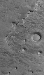
This Mars Global Surveyor (MGS) Mars Orbiter Camera (MOC) image shows an eroded landscape occurring west of Sinus Meridiani, the region in which the Mars Exploration Rover, Opportunity, landed nearly a year ago. The bedrock at this location is buried beneath a mantle of dust, sand, and granules, but remnants of younger layers of bedrock now stand high in the form of buttes in the lower right quarter of the image. The two circular mesas were once meteor impact craters. They were filled, buried, and fossilized within the rock, then later exhumed. This scene is located near 1.5°N, 6.2°W. The picture covers an area about 3 km (1.9 mi) across, and is illuminated by sunlight from the lower left.
Cataloging Keywords:
| Name | Value | Additional Values |
|---|---|---|
| Target | Mars | |
| System | ||
| Target Type | Planet | |
| Mission | Mars Global Surveyor (MGS) | Mars Exploration Rover (MER) |
| Instrument Host | Mars Global Surveyor | Opportunity (MER-B) |
| Host Type | Orbiter | Rover |
| Instrument | Mars Orbiter Camera (MOC) | |
| Detector | ||
| Extra Keywords | Crater, Dust, Grayscale, Impact | |
| Acquisition Date | ||
| Release Date | 2005-01-07 | |
| Date in Caption | 2004-01-07 | |
| Image Credit | NASA/JPL/Malin Space Science Systems | |
| Source | photojournal.jpl.nasa.gov/catalog/PIA07215 | |
| Identifier | PIA07215 | |
