
|
Varied Terrain
- Click the image above for a larger view
- Full-Res JPEG (305 x 261) (10.6 kB)
- Full-Res TIFF (305 x 261) (69.0 kB)
Caption:
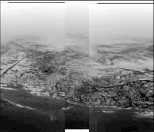
This composite was produced from images returned yesterday, January 14, 2005, by the European Space Agency's Huygens probe during its successful descent to land on Titan. It shows the boundary between the lighter-colored uplifted terrain, marked with what appear to be drainage channels, and darker lower areas.
These images were taken from an altitude of about 8 kilometers (about 5 miles) and a resolution of about 20 meters (about 65 feet) per pixel. The images were taken by the Descent Imager/Spectral Radiometer, one of two NASA instruments on the probe.
Background Info:
The Cassini-Huygens mission is a cooperative project of NASA, the European Space Agency and the Italian Space Agency. The Jet Propulsion Laboratory, a division of the California Institute of Technology in Pasadena, manages the Cassini-Huygens mission for NASA's Science Mission Directorate, Washington, D.C. The Cassini orbiter and its two onboard cameras were designed, developed and assembled at JPL. The Descent Imager/Spectral team is based at the University of Arizona, Tucson, Ariz.
For more information about the Cassini-Huygens mission visit http://saturn.jpl.nasa.gov/home/index.cfm .
Cataloging Keywords:
| Name | Value | Additional Values |
|---|---|---|
| Target | Titan | |
| System | Saturn | |
| Target Type | Satellite | |
| Mission | Cassini-Huygens | |
| Instrument Host | Huygens Probe | |
| Host Type | Probe | Lander |
| Instrument | Descent Imager/Spectral Radiometer (DISR) | |
| Detector | ||
| Extra Keywords | Grayscale | |
| Acquisition Date | ||
| Release Date | 2005-01-15 | |
| Date in Caption | 2005-01-14 | |
| Image Credit | NASA/JPL/ESA/University of Arizona | |
| Source | photojournal.jpl.nasa.gov/catalog/PIA07231 | |
| Identifier | PIA07231 | |