|
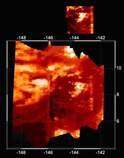
Infrared Image of Titan Volcano
- Click the image above for a larger view
- Full-Res JPEG (435 x 555) (31.4 kB)
- Full-Res TIFF (435 x 555) (725.3 kB)
Caption:
This high-resolution infrared image was taken during the Cassini spacecraft's closest approach to Titan on Oct. 26, 2004. These images were obtained by Cassini's visual and infrared mapping spectrometer instrument and show a bright, circular feature (8.5 degrees latitude, minus 143.5 degrees longitude) with two elongated wings extending westwards. Scientists think this feature might be a volcano.
The resolution in the image varies from 2.6 kilometers (1.6 miles) per pixel to 1.8 kilometers (1.1 miles) per pixel.
Background Info:
The Cassini-Huygens mission is a cooperative project of NASA, the European Space Agency and the Italian Space Agency. The Jet Propulsion Laboratory, a division of the California Institute of Technology in Pasadena, manages the mission for NASA's Science Mission Directorate, Washington, D.C. The Cassini orbiter and its two onboard cameras were designed, developed and assembled at JPL. The visual and infrared mapping spectrometer team is based at the University of Arizona.
For more information about the Cassini-Huygens mission visit http://saturn.jpl.nasa.gov . The visual and infrared mapping spectrometer team homepage is at http://wwwvims.lpl.arizona.edu .
Cataloging Keywords:
| Name | Value | Additional Values |
|---|---|---|
| Target | Titan | |
| System | Saturn | |
| Target Type | Satellite | |
| Mission | Cassini-Huygens | |
| Instrument Host | Cassini Orbiter | |
| Host Type | Orbiter | |
| Instrument | Visual and Infrared Mapping Spectrometer (VIMS) | |
| Detector | ||
| Extra Keywords | Color, Infrared, Volcano | |
| Acquisition Date | ||
| Release Date | 2005-06-08 | |
| Date in Caption | 2004-10-26 | |
| Image Credit | NASA/JPL/University of Arizona / LPL | |
| Source | photojournal.jpl.nasa.gov/catalog/PIA07962 | |
| Identifier | PIA07962 | |