|
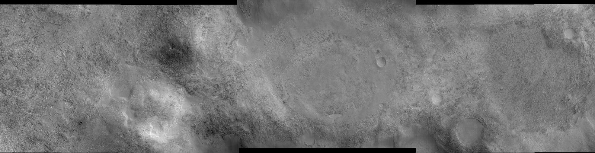
Landscape Northeast of Halley Crater
- Click the image above for a larger view
- Full-Res JPEG (20081 x 5164) (21.2 MB)
- Full-Res TIFF (20081 x 5164) (103.7 MB)
Caption:
This image shows a landscape west of Mars' Argyre impact basin and northeast of Halley Crater. The large but faint circular feature near the center of the image is an unnamed impact crater about 7.5 kilometers (4.7 miles) in diameter. It has been all but erased by geological (and probably ice-related) processes. In fact, the majority of impact craters in this image have been modified from their original shapes, some undoubtedly beyond recognition. Only a few small craters remain pristine. The most prevalent surface type in this image is rough, dissected terrain, which is characterized by a complex pattern of knobs, pits, ridges and valleys. In places the rough terrain has been covered by a younger material that appears flat, smooth and nearly featureless. The smooth material may have been emplaced as muddy or icy debris. It filled low-lying areas (most notably craters) and surrounded higher features, preserving islands of rough terrain. Wind-formed dunes have formed atop some of the smooth material, and diagonal streaks on the right side of the image may be due to the winds. Images such as this show the importance of water (liquid and/or ice), wind, and impacts in shaping the surface of Mars.
This image was taken by the High Resolution Imaging Science Experiment (HiRISE) camera onboard NASA's Mars Reconnaissance Orbiter spacecraft on March 24, 2006. The image is centered at 47.14 degrees south latitude, 302.00 degrees east longitude. It is oriented such that north is 7 degrees to the left of up. The range to the target was 1,699 kilometers (1,056 miles). At this distance the image scale is 1.70 meter (5.58 feet) per pixel in the center portion of the image, so objects as small as 5.1 meter (16.7 feet) are resolved. In the side regions the pixels were binned 2x2 to a scale of 3.4 meters (11.2 feet) per pixel. The camera has a total of 10 red-bandpass CCD detectors, and in this image the first 4 CCDs on the left and the last 3 on the right were binned 2x2, while 3 in the middle returned data at full resolution. In total this image is 34.08 kilometers (21.18 miles) or 20,081 pixels wide and 8.50 kilometers (5.28 miles) or 5,164 pixels high. The image was taken at a local Mars time of 07:27 and the scene is illuminated from the upper right with a solar incidence angle of 84.5 degrees, thus the sun was about 5.5 degrees above the horizon. At an Ls of 29 degrees (with Ls an indicator of Mars' position in its orbit around the sun), the season on Mars is southern autumn.
Background Info:
Images from the High Resolution Imaging Science Experiment and additional information about the Mars Reconnaissance Orbiter are available online at: http://www.nasa.gov/mro or http://HiRISE.lpl.arizona.edu . For information about NASA and agency programs on the Web, visit: http://www.nasa.gov .
JPL, a division of the California Institute of Technology in Pasadena, manages the Mars Reconnaissance Orbiter for NASA's Science Mission Directorate, Washington. Lockheed Martin Space Systems is the prime contractor for the project and built the spacecraft. The HiRISE camera was built by Ball Aerospace and Technology Corporation and is operated by the University of Arizona.
Cataloging Keywords:
| Name | Value | Additional Values |
|---|---|---|
| Target | Mars | |
| System | ||
| Target Type | Planet | |
| Mission | Mars Reconnaissance Orbiter (MRO) | |
| Instrument Host | Mars Reconnaissance Orbiter | |
| Host Type | Orbiter | |
| Instrument | High Resolution Imaging Science Experiment (HiRISE) | |
| Detector | ||
| Extra Keywords | Crater, Dune, Grayscale, Impact, Water | |
| Acquisition Date | ||
| Release Date | 2006-04-07 | |
| Date in Caption | 2006-03-24 | |
| Image Credit | NASA/JPL/University of Arizona | |
| Source | photojournal.jpl.nasa.gov/catalog/PIA08048 | |
| Identifier | PIA08048 | |