|
First HiRISE Image of Mars
- Click the image above for a larger view
- Full-Res JPEG (20081 x 9523) (16.7 MB)
- Full-Res TIFF (20081 x 9523) (191.2 MB)
Caption:
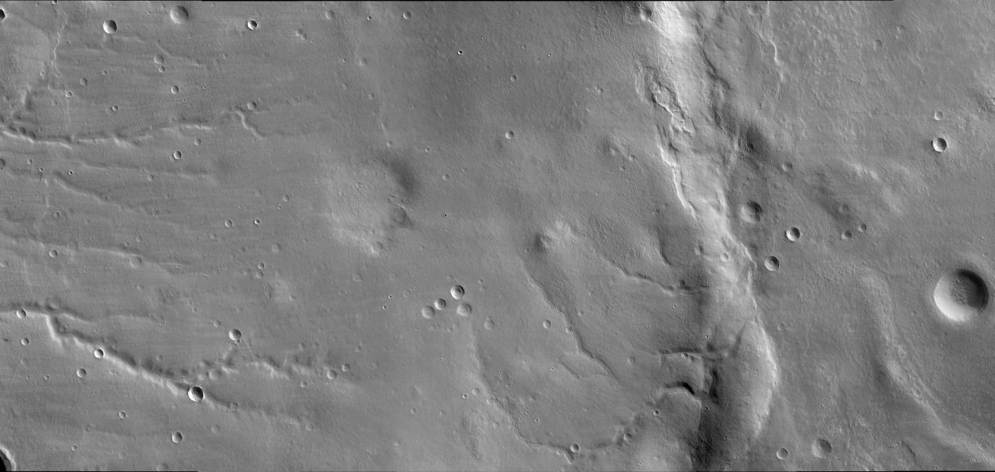
The first image of Mars by the High Resolution Imaging Science Experiment (HiRISE) on NASA's Mars Reconnaissance Orbiter shows a story of geologic change in the eastern Bosporos Planum region. Old stream valleys cut into the flanks of a gently sloping mountain range in the center of the image. Layers of smooth-textured deposits have mantled the stream valleys and many impact craters. Wind and sublimation of water or carbon dioxide ice have partially eroded patches of the smooth-textured deposits, leaving behind areas of layered and hummocky terrain. A prominent ridge that extends from the top to the bottom of the image dominates the scene. This ridge formed above a thrust fault, a type of fault that occurs when the surface of a planet is compressed. On planetary surfaces, such fault-related ridges are termed "wrinkle ridges." They are commonly observed on Mars, as well as on Earth's moon and on Venus and Mercury. The wrinkle ridge imaged here is named Ogygis Rupes. This wrinkle ridge has deformed several valleys and impact craters. Throughout the scene, geologically young sand dunes are present within stream valleys and some impact craters. The area is also sprinkled with many small young impact craters, which are distinguished by sharp crater rims and bright or dark halos of ejected material. This image demonstrates how a single HiRISE image can capture a multitude of geologic processes.
This view results from further processing of an image released quickly after the data was received from the camera. See PIA08014 . It was taken by HiRISE on March 24, 2006. The image is centered at 33.65 degrees south latitude, 305.07 degrees east longitude. It is oriented such that north is 7 degrees to the left of up. The range to the target was 2,493 kilometers (1,549 miles). At this distance the image scale is 2.49 meters (8.17 feet) per pixel, so objects as small as 7.5 meters (24.6 feet) are resolved. In total this image is 49.92 kilometers (31.02 miles) or 20,081 pixels wide and 23.66 kilometers (14.70 miles) or 9,523 pixels long. The image was taken at a local Mars time of 07:33 and the scene is illuminated from the upper right with a solar incidence angle of 78 degrees, thus the sun was 12 degrees above the horizon. At an Ls of 29 degrees (with Ls an indicator of Mars' position in its orbit around the sun), the season on Mars is southern autumn.
Background Info:
Images from the High Resolution Imaging Science Experiment and additional information about the Mars Reconnaissance Orbiter are available online at: http://www.nasa.gov/mro or http://HiRISE.lpl.arizona.edu . For information about NASA and agency programs on the Web, visit: http://www.nasa.gov .
JPL, a division of the California Institute of Technology in Pasadena, manages the Mars Reconnaissance Orbiter for NASA's Science Mission Directorate, Washington. Lockheed Martin Space Systems is the prime contractor for the project and built the spacecraft. The HiRISE camera was built by Ball Aerospace and Technology Corporation and is operated by the University of Arizona.
Cataloging Keywords:
| Name | Value | Additional Values |
|---|---|---|
| Target | Mars | |
| System | ||
| Target Type | Planet | |
| Mission | Mars Reconnaissance Orbiter (MRO) | |
| Instrument Host | Mars Reconnaissance Orbiter | |
| Host Type | Orbiter | |
| Instrument | High Resolution Imaging Science Experiment (HiRISE) | |
| Detector | ||
| Extra Keywords | Crater, Dune, Grayscale, Impact, Mountain, Water | |
| Acquisition Date | ||
| Release Date | 2006-04-07 | |
| Date in Caption | 2006-03-24 | |
| Image Credit | NASA/JPL/University of Arizona | |
| Source | photojournal.jpl.nasa.gov/catalog/PIA08060 | |
| Identifier | PIA08060 | |