
|
A Folded Surface
- Click the image above for a larger view
- Full-Res JPEG (962 x 512) (63.0 kB)
- Full-Res TIFF (962 x 512) (493.3 kB)
Caption:
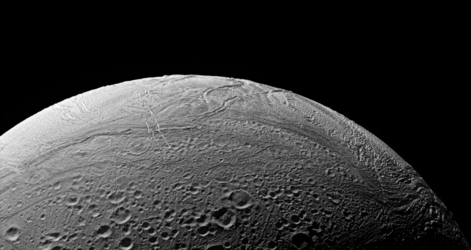
The wrinkled border of Enceladus' south polar region snakes across this view, separating fresher, younger terrain from more ancient, cratered provinces.
This is the region of Enceladus (505 kilometers, or 314 miles across) that is known to be presently geologically active. At right are clearly visible ridges and troughs thought to be caused by compressional stresses across the icy surface.
The image was taken in polarized green light with the Cassini spacecraft narrow-angle camera on Sept. 9, 2006 at a distance of approximately 66,000 kilometers (41,000 miles) from Enceladus and at a Sun-Enceladus-spacecraft, or phase, angle of 104 degrees. Image scale is 396 meters (1,300 feet) per pixel.
Background Info:
The Cassini-Huygens mission is a cooperative project of NASA, the European Space Agency and the Italian Space Agency. The Jet Propulsion Laboratory, a division of the California Institute of Technology in Pasadena, manages the mission for NASA's Science Mission Directorate, Washington, D.C. The Cassini orbiter and its two onboard cameras were designed, developed and assembled at JPL. The imaging operations center is based at the Space Science Institute in Boulder, Colo.
For more information about the Cassini-Huygens mission visit http://saturn.jpl.nasa.gov/home/index.cfm . The Cassini imaging team homepage is at http://ciclops.org .
Cataloging Keywords:
| Name | Value | Additional Values |
|---|---|---|
| Target | Enceladus | |
| System | Saturn | |
| Target Type | Satellite | |
| Mission | Cassini-Huygens | |
| Instrument Host | Cassini Orbiter | |
| Host Type | Orbiter | |
| Instrument | Imaging Science Subsystem (ISS) | |
| Detector | Narrow Angle Camera | |
| Extra Keywords | Crater, Grayscale, Visual | |
| Acquisition Date | ||
| Release Date | 2006-10-04 | |
| Date in Caption | ||
| Image Credit | NASA/JPL/Space Science Institute | |
| Source | photojournal.jpl.nasa.gov/catalog/PIA08280 | |
| Identifier | PIA08280 | |