
|
Map of Titan - October 2007
- Click the image above for a larger view
- Full-Res JPEG (4374 x 2430) (739.7 kB)
- Full-Res TIFF (4374 x 2430) (31.9 MB)
Caption:
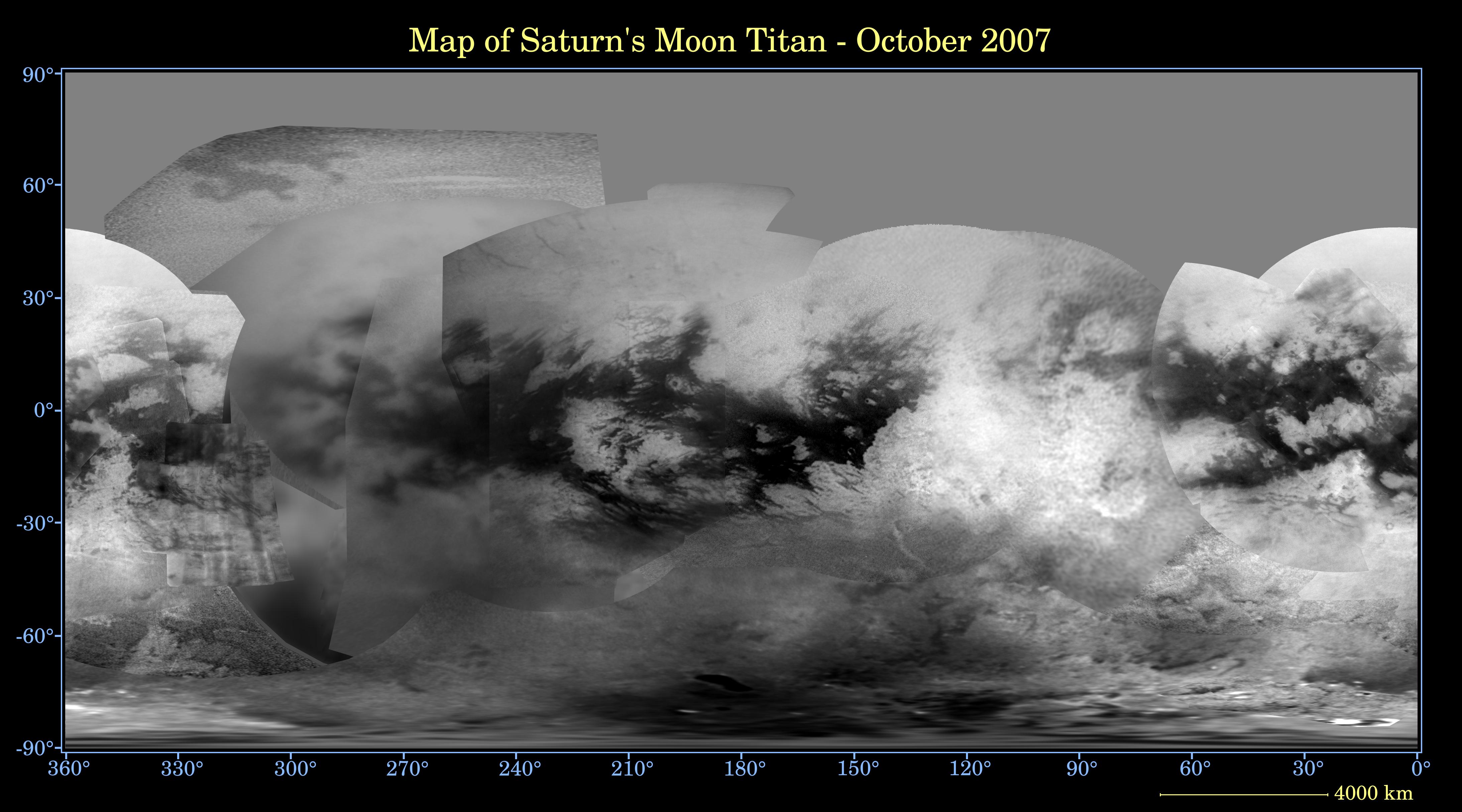
This global digital map of Titan was created using images taken by the Cassini spacecraft imaging science subsystem.
The images were taken using a filter centered at 938 nanometers, allowing researchers to examine albedo (or inherent brightness) variations across the surface of Titan. Due to the scattering of light by Titan's dense atmosphere, no topographic shading is visible in these images.
The map is an equidistant projection and has a scale of 4 kilometers (2.5 miles) per pixel. Actual resolution varies greatly across the map, with the best coverage (close to the map scale) near the center and edges of the map and the worst coverage on the trailing hemisphere (centered around 270 degrees west longitude).
Imaging coverage in the northern polar region is only just beginning to improve, and will continue to do so over the next couple of years, as Titan approaches vernal equinox in August 2009 and the north pole comes out of shadow. Large, dark and presumably liquid-hydrocarbon-filled seas are becoming visible at high latitudes (see also PIA08365 ).
The mean radius of Titan used for projection of this map is 2,575 kilometers (1,600 miles). Until a control network is created for Titan, the moon is assumed to be spherical.
Background Info:
The Cassini-Huygens mission is a cooperative project of NASA, the European Space Agency and the Italian Space Agency. The Jet Propulsion Laboratory, a division of the California Institute of Technology in Pasadena, manages the mission for NASA's Science Mission Directorate, Washington, D.C. The Cassini orbiter and its two onboard cameras were designed, developed and assembled at JPL. The imaging operations center is based at the Space Science Institute in Boulder, Colo.
For more information about the Cassini-Huygens mission visit http://saturn.jpl.nasa.gov/home/index.cfm . The Cassini imaging team homepage is at http://ciclops.org .
Cataloging Keywords:
| Name | Value | Additional Values |
|---|---|---|
| Target | Titan | |
| System | Saturn | |
| Target Type | Satellite | |
| Mission | Cassini-Huygens | |
| Instrument Host | Cassini Orbiter | |
| Host Type | Orbiter | |
| Instrument | Imaging Science Subsystem (ISS) | |
| Detector | ||
| Extra Keywords | Atmosphere, Color, Map, Shadow | |
| Acquisition Date | ||
| Release Date | 2007-10-15 | |
| Date in Caption | ||
| Image Credit | NASA/JPL/Space Science Institute | |
| Source | photojournal.jpl.nasa.gov/catalog/PIA08399 | |
| Identifier | PIA08399 | |