|
Close Brush with Enceladus
- Click the image above for a larger view
- Full-Res JPEG (1225 x 806) (123.3 kB)
- Full-Res TIFF (1225 x 806) (990.2 kB)
Caption:
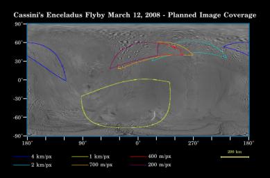
This map of the surface of Saturn's moon Enceladus, generated from images taken by NASA's Cassini and Voyager spacecraft, illustrates the imaging coverage planned for Cassini's very close flyby of the geologically active moon on March 12, 2008.
This flyby will be Cassini's closest approach to Enceladus so far, the fourth and final Enceladus flyby of the four-year prime mission, and the first of four close brushes with this moon that have been proposed for 2008. At closest approach, the spacecraft will be only about 50 kilometers (30 miles) above the surface of Enceladus, and will pass the moon at a speed of about 14 kilometers (9 miles) per second. Enceladus is 505 kilometers (314 miles) across.
During this flyby, as well as the flyby on Oct. 9, 2008, Cassini's in-situ instruments will make the most of the remarkably close encounters. The imaging cameras and the other optical remote sensing instruments will get a better look at the moon during the flybys that have been proposed for Aug. 11 and Oct. 31. Radar will acquire albedo measurements during the March and Oct. encounters.
Colored lines on the map enclose regions that will be covered at different imaging scales as Cassini encounters Enceladus. The highest-resolution images, about 200 meters (660 feet) per pixel, will be obtained over the cratered terrains of the northern hemisphere, prior to closest approach. Cassini will also acquire images soon after closest approach. However, the moon will be in eclipse during this time—sitting within Saturn's shadow—and surface features will likely not be visible. Additional images at resolutions above 700 meters per pixel (2,300 feet) will be acquired following the eclipse period.
Background Info:
The Cassini-Huygens mission is a cooperative project of NASA, the European Space Agency and the Italian Space Agency. The Jet Propulsion Laboratory, a division of the California Institute of Technology in Pasadena, manages the mission for NASA's Science Mission Directorate, Washington, D.C. The Cassini orbiter and its two onboard cameras were designed, developed and assembled at JPL. The imaging operations center is based at the Space Science Institute in Boulder, Colo.
For more information about the Cassini-Huygens mission visit http://saturn.jpl.nasa.gov/home/index.cfm . The Cassini imaging team homepage is at http://ciclops.org .
Cataloging Keywords:
| Name | Value | Additional Values |
|---|---|---|
| Target | Enceladus | |
| System | Saturn | |
| Target Type | Satellite | |
| Mission | Cassini-Huygens | Voyager |
| Instrument Host | Cassini Orbiter | |
| Host Type | Orbiter | Flyby Spacecraft |
| Instrument | Radar Mapper | |
| Detector | ||
| Extra Keywords | Color, Crater, Eclipse, Map, Radar, Shadow | |
| Acquisition Date | ||
| Release Date | 2008-03-06 | |
| Date in Caption | 2008-03-12 | 2008-10-09 |
| Image Credit | NASA/JPL-Caltech/Space Science Institute | |
| Source | photojournal.jpl.nasa.gov/catalog/PIA08408 | |
| Identifier | PIA08408 | |
