|
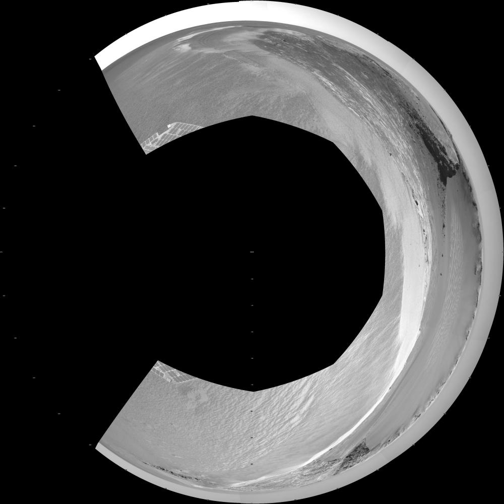
‘Victoria Crater’ from ‘Duck Bay’ (Polar Projection)
- Click the image above for a larger view
- Full-Res JPEG (4071 x 4071) (927.8 kB)
- Full-Res TIFF (4071 x 4071) (16.6 MB)
Caption:
NASA's Mars rover Opportunity edged 3.7 meters (12 feet) closer to the top of the "Duck Bay" alcove along the rim of "Victoria Crater" during the rover's 952nd Martian day, or sol (overnight Sept. 27 to Sept. 28), and gained this vista of the crater. The rover's navigation camera took the seven exposures combined into this mosaic view of the crater's interior. This crater has been the mission's long-term destination for the past 21 Earth months.
The far side of the crater is about 800 meters (one-half mile) away. The rim of the crater is composed of alternating promontories, rocky points towering approximately 70 meters (230 feet) above the crater floor, and recessed alcoves, such as Duck Bay. The bottom of the crater is covered by sand that has been shaped into ripples by the Martian wind. The rocky cliffs in the foreground have been informally named "Cape Verde," on the left, and "Cabo Frio," on the right.
Victoria Crater is about five times wider than "Endurance Crater," which Opportunity spent six months examining in 2004, and about 40 times wider than "Eagle Crater," where Opportunity first landed. The great lure of Victoria is an expectation that the thick stack of geological layers exposed in the crater walls could reveal the record of past environmental conditions over a much greater span of time than Opportunity has read from rocks examined earlier in the mission.
This view is presented as a polar projection with geometric seam correction.
Cataloging Keywords:
| Name | Value | Additional Values |
|---|---|---|
| Target | Mars | |
| System | ||
| Target Type | Planet | |
| Mission | Mars Exploration Rover (MER) | |
| Instrument Host | Opportunity (MER-B) | |
| Host Type | Rover | |
| Instrument | Navigation Camera (Navcam) | |
| Detector | ||
| Extra Keywords | Crater, Grayscale | |
| Acquisition Date | ||
| Release Date | 2006-09-28 | |
| Date in Caption | ||
| Image Credit | NASA/JPL-Caltech | |
| Source | photojournal.jpl.nasa.gov/catalog/PIA08785 | |
| Identifier | PIA08785 | |