|
Opportunity Traverse Map, ‘Eagle’ to ‘Victoria’
- Click the image above for a larger view
- Full-Res JPEG (2485 x 2749) (657.4 kB)
- Full-Res TIFF (2485 x 2749) (20.5 MB)
Caption:
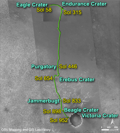
Annotated Image
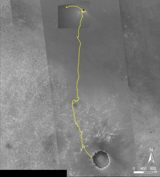
NASA's Mars Exploration Rover Opportunity reached the rim of "Victoria Crater" on Sept. 27, 2006, during the 951st Martian day, or sol, of the rover's work in the Meridian Planum region of Mars. Opportunity drove 9.28 kilometers (5.77 miles) in the explorations that took it from "Eagle Crater," where it landed in January 2004, eastward to "Endurance Crater," which it investigated for about half of 2004, then southward to Victoria.
This map of Opportunity's trek so far is overlaid onto images taken by the Mars Orbiter Camera on NASA's Mars Global Surveyor. Victoria is about 800 meters (one-half mile) in diameter, or about five times wider than Endurance and 40 times wider than Eagle. The scale bar at lower right shows the length of 800 meters (0.50 mile). North is up.
The Martian sol dates in the annotated image are as follows:
sol 58 was March 24, 2004
sol 315 was December 12, 2004
sol 446 was April 26, 2005
sol 654 was November 25, 2005
sol 833 was May 28, 2006
sol 898 was August 3, 2006
sol 952 was September 28, 2006
Cataloging Keywords:
| Name | Value | Additional Values |
|---|---|---|
| Target | Mars | |
| System | ||
| Target Type | Planet | |
| Mission | Mars Global Surveyor (MGS) | Mars Exploration Rover (MER) |
| Instrument Host | Mars Global Surveyor | Opportunity (MER-B) |
| Host Type | Orbiter | Rover |
| Instrument | Mars Orbiter Camera (MOC) | |
| Detector | ||
| Extra Keywords | Color, Crater, Map | |
| Acquisition Date | ||
| Release Date | 2006-10-06 | |
| Date in Caption | 2004-03-24 | 2004-12-12, 2005-04-26, 2005-11-25, 2006-05-28, 2006-08-03, 2006-09-28 |
| Image Credit | NASA/JPL/MSSS/Ohio State University | |
| Source | photojournal.jpl.nasa.gov/catalog/PIA08811 | |
| Identifier | PIA08811 | |