|
A Fresh Crater Drills to Tharsis Bedrock
- Click the image above for a larger view
- Full-Res JPEG (758 x 1550) (92.8 kB)
- Full-Res TIFF (758 x 1550) (3.5 MB)
Caption:
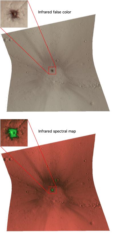
The Compact Reconnaissance Imaging Spectrometer for Mars (CRISM) took this image of a newly formed impact crater in the Tharsis region of Mars at 1316 UTC (8:16 a.m. EST) on Jan. 13, 2007, near 17.0 degrees north latitude, 246.4 degrees east longitude. CRISM's image was taken in 544 colors covering 0.36-3.92 micrometers, and shows features as small as 20 meters (66 feet) across. The region covered by the image is just over 10 kilometers (6 miles) wide at its narrowest point.
The Tharsis region is a high volcanic plateau that stands about 5 kilometers (3 miles) above the surrounding plains. The rocks forming Tharsis are younger than in most parts of mars, as evidenced by their low density of craters. The best estimate of their age is comparable to the age of Shergotty-class meteorites thought to originate from Mars. However, Tharsis is covered by a nearly unbroken, meters-thick layer of dust that has frustrated all attempts to measure its bedrock composition remotely, and to determine if it matches the composition of Shergotty-class meteorites.
The recent discovery of dark, newly formed impact craters on Mars has provided the CRISM team a chance, finally, to measure the rocks that make up Tharsis. Over the lifetime of the Mars Global Surveyor mission, its high-resolution Mars Orbiter Camera monitored the surface and documented the very recent formation of some two dozen small impact craters. Several of them are in Tharsis and pierce the plateau's dust blanket to expose bedrock. MRO's instruments have been trained on these "drill holes" into Mars' volcanic crust, including the crater shown here.
The top image was constructed from three infrared wavelengths that usually highlight compositional variations. This image shows the impact crater, a ring of dark, excavated rock (inset), and a surrounding system of rays. Crater rays are common around young impact craters, and they form when ejected boulders reimpact the surface and stir up the local rock and soil. The colors are bland because the scene is dominated by dust except for the dark crater and the ejecta immediately surrounding it.
The bottom image is a spectral map constructed using measurements of the 544-color spectra that separate dust and rock. The bright, deep orange areas are undisturbed dust. The crater rays' chocolate color in this rendition shows that they are slightly darker, more packed-down soil that was exposed by reimpacting boulders. The bright green color immediately around the new crater (inset) is where mafic rock (rock rich in the iron- and magnesium-containing minerals pyroxene and olivine) have been exposed.
Background Info:
CRISM's mission: Find the spectral fingerprints of aqueous and hydrothermal deposits and map the geology, composition and stratigraphy of surface features. The instrument will also watch the seasonal variations in Martian dust and ice aerosols, and water content in surface materials -- leading to new understanding of the climate.
The Compact Reconnaissance Imaging Spectrometer for Mars (CRISM) is one of six science instruments on NASA's Mars Reconnaissance Orbiter. Led by The Johns Hopkins University Applied Physics Laboratory, the CRISM team includes expertise from universities, government agencies and small businesses in the United States and abroad.
Cataloging Keywords:
| Name | Value | Additional Values |
|---|---|---|
| Target | Mars | |
| System | ||
| Target Type | Planet | |
| Mission | Mars Reconnaissance Orbiter (MRO) | Mars Global Surveyor (MGS) |
| Instrument Host | Mars Reconnaissance Orbiter | Mars Global Surveyor |
| Host Type | Orbiter | |
| Instrument | Compact Reconnaissance Imaging Spectrometer for Mars (CRISM) | Mars Orbiter Camera (MOC) |
| Detector | ||
| Extra Keywords | Color, Crater, Dust, Impact, Infrared, Map, Thermal, Volcano, Water | |
| Acquisition Date | ||
| Release Date | 2007-02-13 | |
| Date in Caption | 2007-01-13 | |
| Image Credit | NASA/JPL/JHUAPL | |
| Source | photojournal.jpl.nasa.gov/catalog/PIA09195 | |
| Identifier | PIA09195 | |