|
Hyperion’s Kaleidoscope of Color
- Click the image above for a larger view
- Full-Res JPEG (942 x 995) (79.9 kB)
- Full-Res TIFF (942 x 995) (2.8 MB)
Caption:
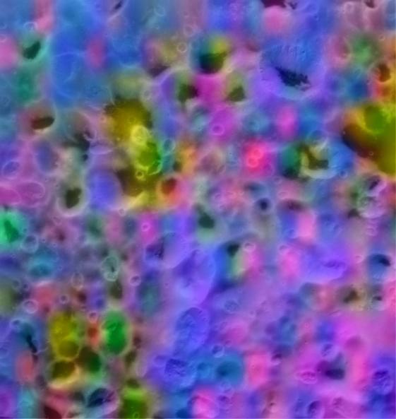
This is a color map of the composition of a portion of Saturn's moon Hyperion's surface about 75 kilometers (45 miles) on a side.
In this map, blue shows the maximum exposure of frozen water, red denotes carbon dioxide ice ("dry ice"), magenta indicates regions of water plus carbon dioxide, yellow is a mix of carbon dioxide and an unidentified material. This map was made with data from the Visual and Infrared Mapping Spectrometer aboard the Cassini spacecraft during its flyby of Hyperion in September 2005.
Background Info:
The Cassini-Huygens mission is a cooperative project of NASA, the European Space Agency and the Italian Space Agency. The Jet Propulsion Laboratory, a division of the California Institute of Technology in Pasadena, manages the mission for NASA's Science Mission Directorate, Washington, D.C. The Cassini orbiter was designed, developed and assembled at JPL. The Visual and Infrared Mapping Spectrometer team is based at the University of Arizona. The imaging operations center is based at the Space Science Institute in Boulder, Colo.
For more information about the Cassini-Huygens mission, visit: http://saturn.jpl.nasa.gov/home/index.cfm . The visual and infrared mapping spectrometer team home page is at: http://wwwvims.lpl.arizona.edu . The Cassini imaging team homepage is at http://ciclops.org .
Cataloging Keywords:
| Name | Value | Additional Values |
|---|---|---|
| Target | Hyperion | |
| System | Saturn | |
| Target Type | Satellite | |
| Mission | Cassini-Huygens | |
| Instrument Host | Cassini Orbiter | |
| Host Type | Orbiter | |
| Instrument | Visual and Infrared Mapping Spectrometer (VIMS) | |
| Detector | ||
| Extra Keywords | Color, Infrared, Map, Water | |
| Acquisition Date | ||
| Release Date | 2007-07-04 | |
| Date in Caption | ||
| Image Credit | NASA/JPL/University of Arizona/Ames/Space Science Institute | |
| Source | photojournal.jpl.nasa.gov/catalog/PIA09215 | |
| Identifier | PIA09215 | |