
|
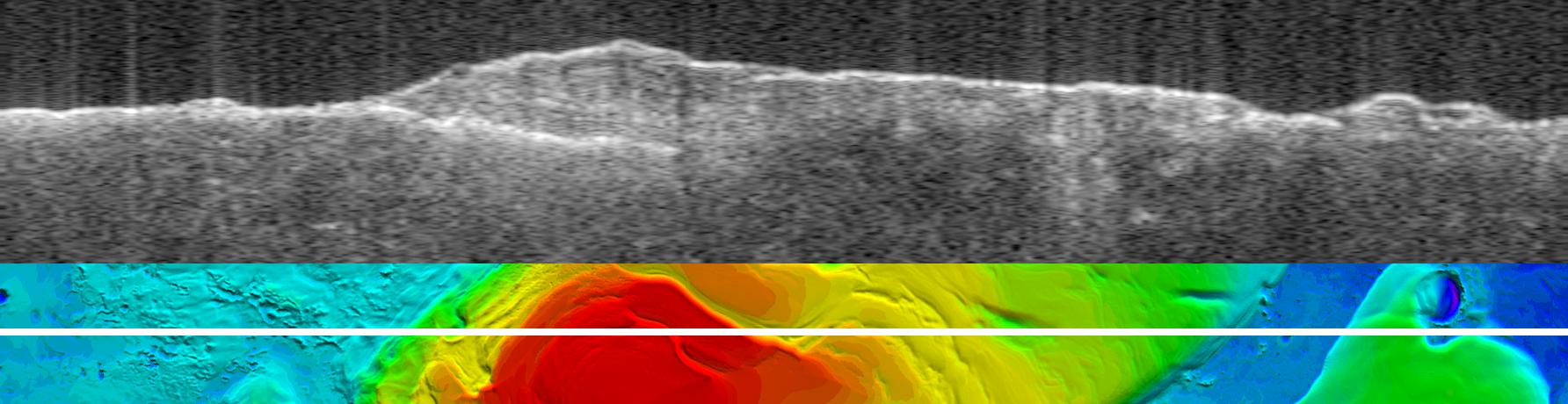
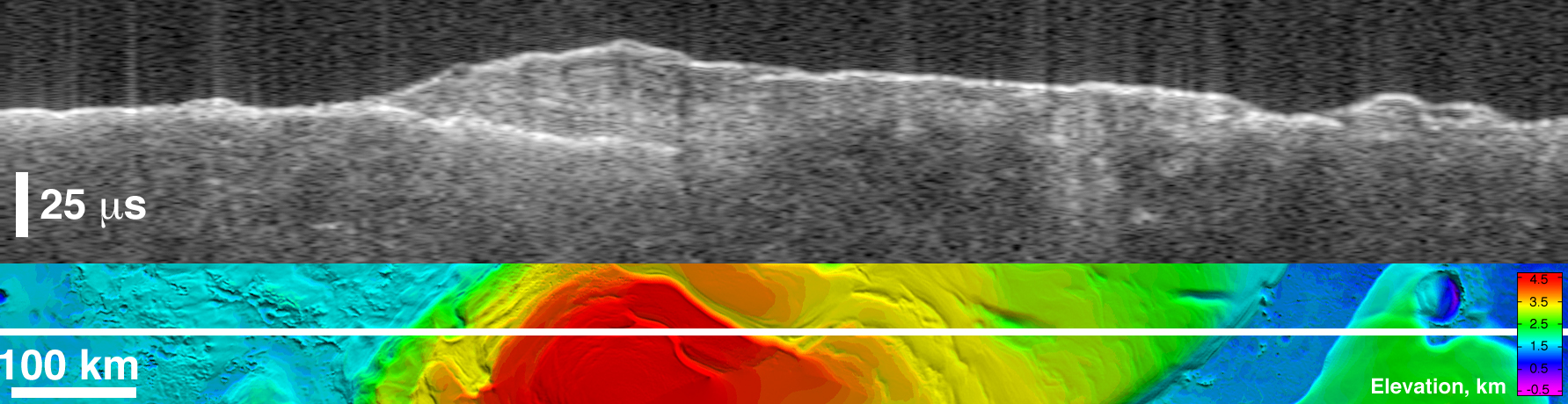
Bright Lower Echo in Radargram of South Polar Layered Deposits
- Click the image above for a larger view
- Full-Res JPEG (1784 x 460) (124.4 kB)
- Full-Res TIFF (1784 x 460) (2.5 MB)
Caption:
Annotated Version
The upper image is a radargram from the Mars Advanced Radar for Subsurface and Ionospheric Sounding (MARSIS), showing data from the subsurface of Mars in the ice-rich layered deposits that surround the south pole. The lower image shows the position of the ground track (white line) on a topographic map of the area based on Mars Orbiter Laser Altimeter data. The images are 1,250 kilometers (775 miles) wide.
The MARSIS echo trace splits into two traces on the left side of the image, at the point where the ground track crosses from the surrounding plains onto the elevated layered deposits. The upper trace is the echo from the surface of the deposits, while the lower trace is interpreted to be the boundary between the lower surface of the deposits and the underlying material. The strength of the lower echo suggests that the intervening material is nearly pure water ice. Near the image center, the bright lower echo abruptly disappears for unknown reasons. The time delay between the two echoes reaches a maximum of 42 microseconds left of center, corresponding to a thickness of 3.5 kilometers (2.2 miles) of ice. The total elevation difference shown in the topographic map is about 4 kilometers (2.5 miles) between the lowest surface (purple) and the highest (red).
Background Info:
MARSIS is an instrument on the European Space Agency's Mars Express orbiter. NASA and the Italian Space Agency jointly funded the instrument. The Mars Orbiter Laser Altimeter flew on NASA's Mars Global Surveyor orbiter.
Cataloging Keywords:
| Name | Value | Additional Values |
|---|---|---|
| Target | Mars | |
| System | ||
| Target Type | Planet | |
| Mission | Mars Express (MEX) | Mars Express, Mars Global Surveyor (MGS) |
| Instrument Host | Mars Express Orbiter | Mars Express, Mars Global Surveyor |
| Host Type | Orbiter | |
| Instrument | Mars Advanced Radar for Subsurface and Ionosphere Sounding (MARSIS) | Mars Orbiter Laser Altimeter (MOLA) |
| Detector | ||
| Extra Keywords | Color, Map, Radar, Water | |
| Acquisition Date | ||
| Release Date | 2007-03-15 | |
| Date in Caption | ||
| Image Credit | NASA/JPL/ASI/ESA/Univ. of Rome/MOLA Science Team | |
| Source | photojournal.jpl.nasa.gov/catalog/PIA09222 | |
| Identifier | PIA09222 | |