|
Lower Boundary of Icy Layers Covering Mars’ South Polar Region
- Click the image above for a larger view
- Full-Res JPEG (2369 x 2558) (938.3 kB)
- Full-Res TIFF (2369 x 2558) (18.2 MB)
Caption:
Annotated Version
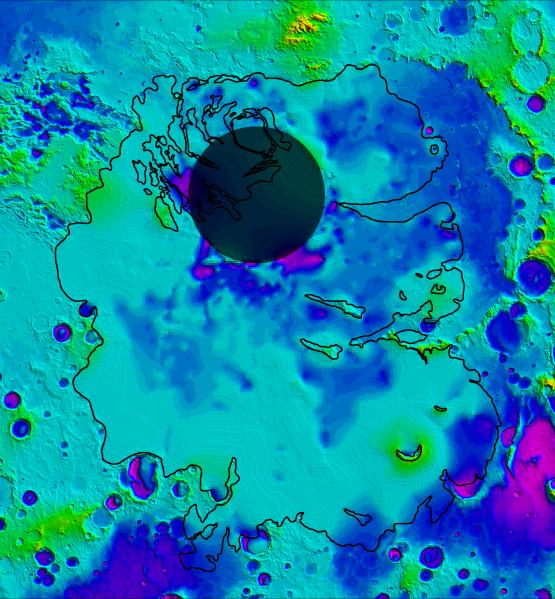
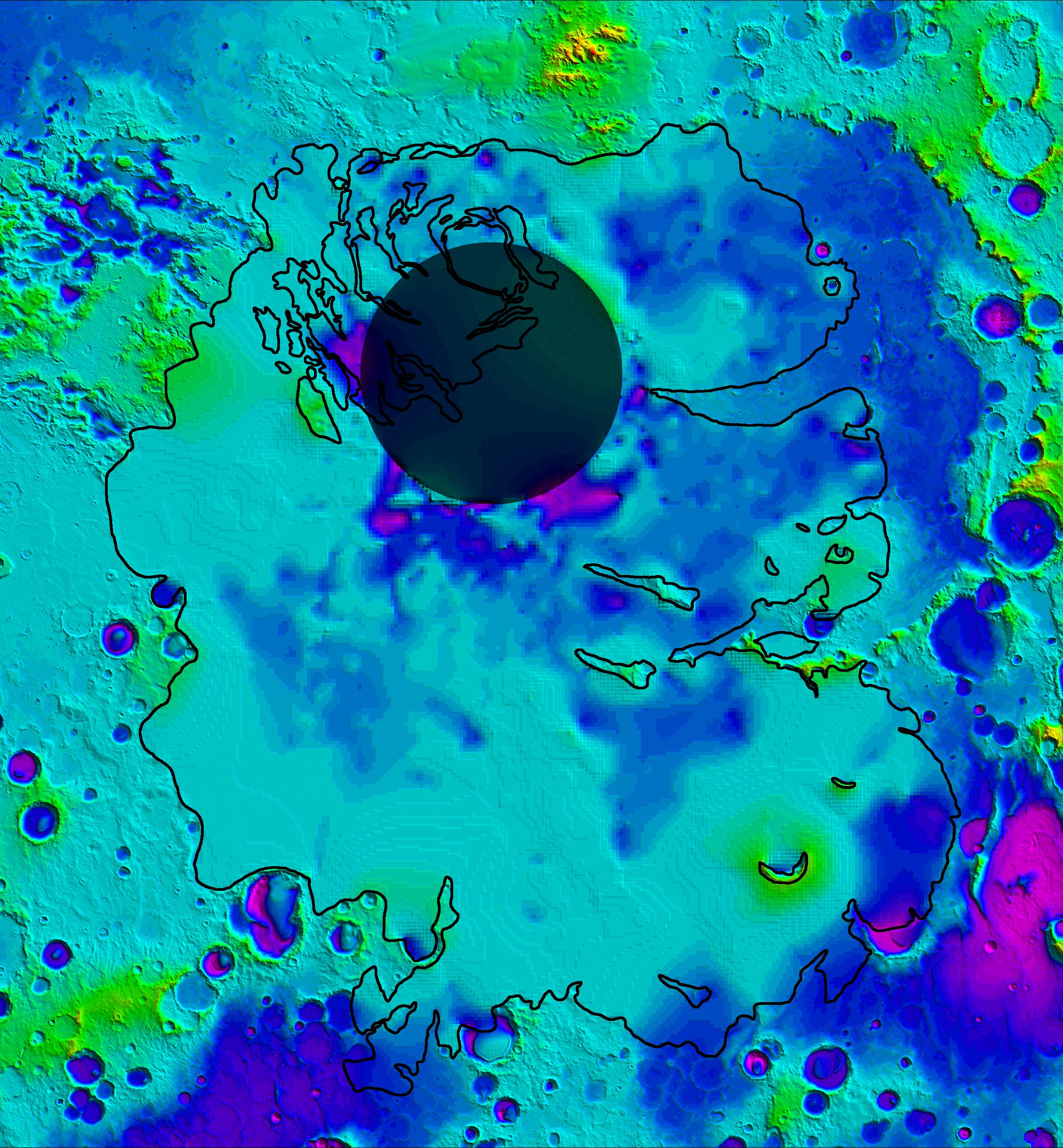
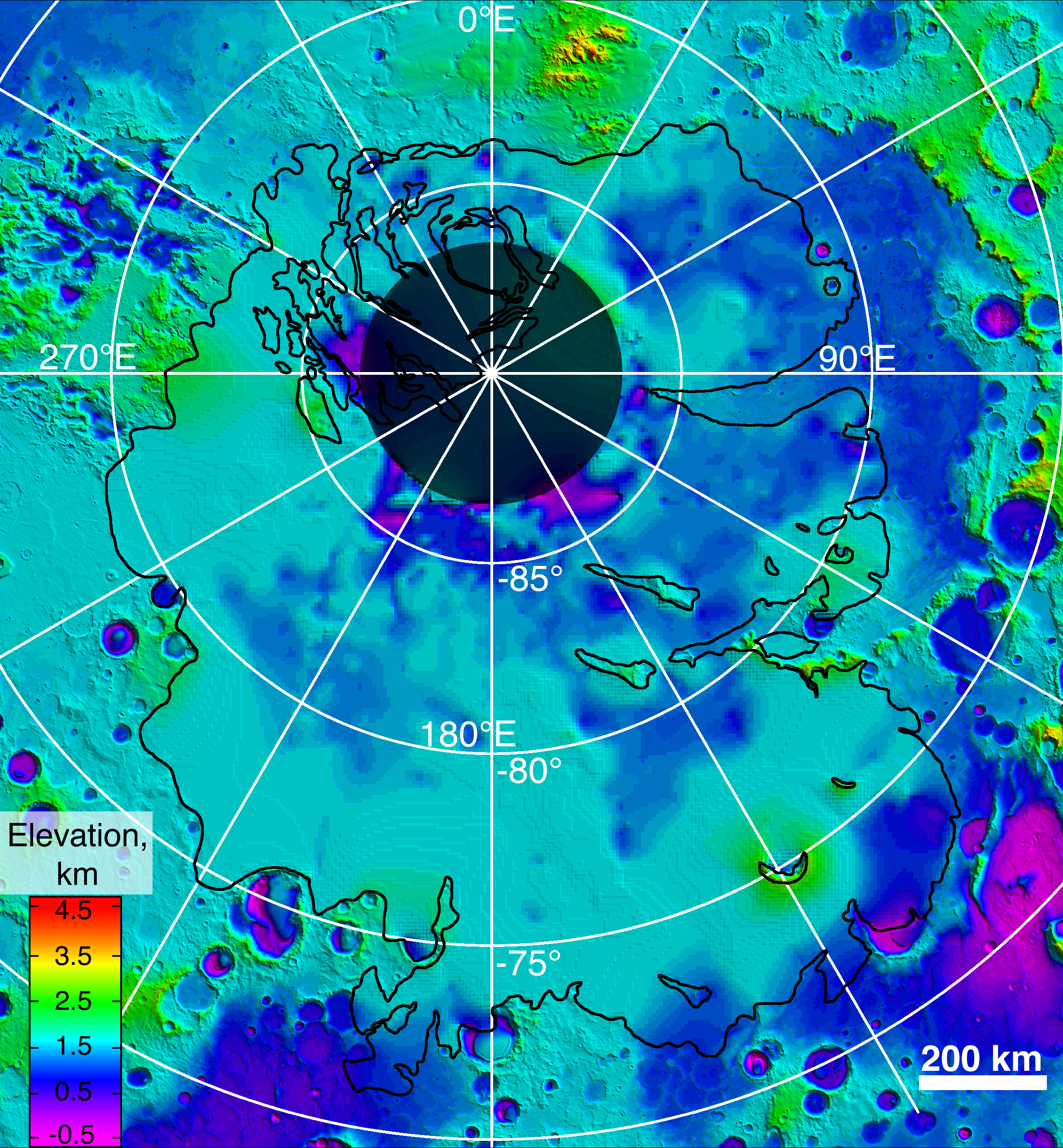
This map shows the topography of the south polar region of Mars, including topography buried by thick deposits of icy material. The map is a combination of surface elevation data acquired by the Mars Orbiter Laser Altimeter aboard NASA's Mars Global Surveyor orbiter, and subsurface elevation data acquired by the Mars Advanced Radar for Subsurface and Ionospheric Sounding (MARSIS) aboard the European Space Agency's Mars Express orbiter.
The black line shows the boundary of the south polar layered deposits, an ice-rich geologic unit that was probed by MARSIS. Elevation values within the black outline, as measured by MARSIS, show the topography at the boundary between the layered deposits and the underlying material, an interface known as the "bed" of the deposits. The elevation of the terrain is shown by colors, with purple and blue representing the lowest areas, and orange and red the highest. The total range of elevation shown is about 5 kilometers (3 miles). The radar data reveal previously undetected features of topography of the bed, including depressions as deep as 1 kilometer (0.6 miles) shown in purple in the near-polar region. The boundary of the layered deposits was mapped by scientists from the U.S. Geological Survey. The dark circle in the upper center is the area poleward of 87 degrees south latitude, where MARSIS data cannot be collected. The map covers an area 1,670 by 1,800 kilometers (1,035 by 1,115 miles).
Background Info:
MARSIS is an instrument on the European Space Agency's Mars Express orbiter. NASA and the Italian Space Agency jointly funded the instrument. The Mars Orbiter Laser Altimeter flew on NASA's Mars Global Surveyor orbiter.
Cataloging Keywords:
| Name | Value | Additional Values |
|---|---|---|
| Target | Mars | |
| System | ||
| Target Type | Planet | |
| Mission | Mars Express (MEX) | Mars Express, Mars Global Surveyor (MGS) |
| Instrument Host | Mars Express Orbiter | Mars Express, Mars Global Surveyor |
| Host Type | Orbiter | |
| Instrument | Mars Advanced Radar for Subsurface and Ionosphere Sounding (MARSIS) | Mars Orbiter Laser Altimeter (MOLA) |
| Detector | ||
| Extra Keywords | Color, Map, Radar | |
| Acquisition Date | ||
| Release Date | 2007-03-15 | |
| Date in Caption | ||
| Image Credit | NASA/JPL/ASI/ESA/Univ. of Rome/MOLA Science Team/USGS | |
| Source | photojournal.jpl.nasa.gov/catalog/PIA09225 | |
| Identifier | PIA09225 | |