|
Delta In Eberswalde
- Click the image above for a larger view
- Full-Res JPEG (2048 x 7151) (2.2 MB)
- Full-Res TIFF (2048 x 7151) (44.0 MB)
Caption:
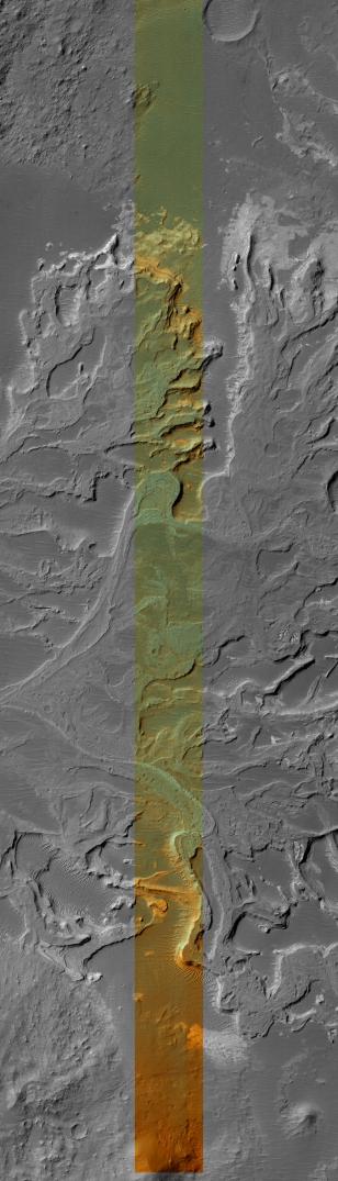
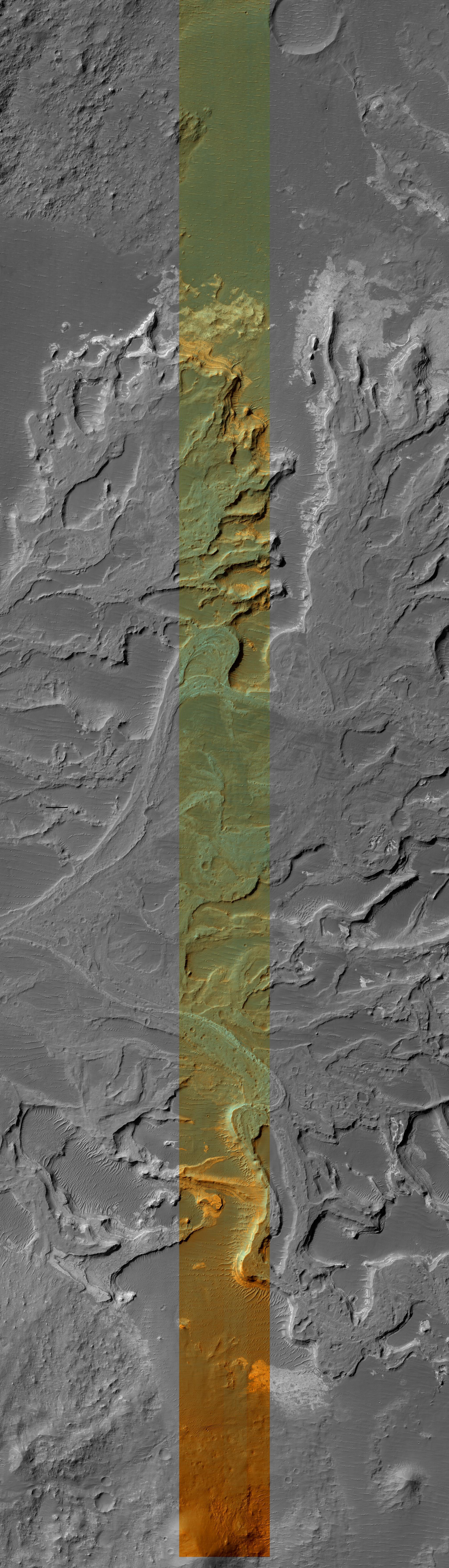
This HiRISE image covers a portion of a delta that partially fills Eberswalde crater in Margaritifer Sinus. The delta was first recognized and mapped using MOC images that revealed various features whose presence required sustained flow and deposition into a lake that once occupied the crater. The HiRISE image resolves meter-scale features that record the migration of channels and delta distributaries as the delta grew over time. Differences in grain-size of sediments within the environments on the delta enable differential erosion of the deposits. As a result, coarser channel deposits are slightly more resistant and stand in relief relative to finer-grained over-bank and more easily eroded distal delta deposits. Close examination of the relict channel deposits confirms the presence of some meter-size blocks that were likely too coarse to have been transported by water flowing within the channels. These blocks may be formed of the sand and gravel that more likely moved along the channels that was lithified and eroded. Numerous meter-scale polygonal structures are common on many surfaces, but mostly those associated with more quiescent depositional environments removed from the channels. The polygons could be the result of deposition of fine-grained sediments that were either exposed and desiccated (dried out), rich in clays that shrunk when the water was removed, turned into rock and then fractured and eroded, or some combination of these processes.
The center swath is composed of images acquired through red and blue-green filters. The color has been enhanced to better show the subtle color differences. It is not natural color or how it would appear to normal human vision.
Image PSP_001336_1560 was taken by the High Resolution Imaging Science Experiment (HiRISE) camera onboard the Mars Reconnaissance Orbiter spacecraft on November 8, 2006. The complete image is centered at -23.8 degrees latitude, 326.4 degrees East longitude. The range to the target site was 256.3 km (160.2 miles). At this distance the image scale is 25.6 cm/pixel (with 1 x 1 binning) so objects ~77 cm across are resolved. The image was taken at a local Mars time of 3:35 PM and the scene is illuminated from the west with a solar incidence angle of 67 degrees, thus the sun was about 23 degrees above the horizon. At a solar longitude of 132.4 degrees, the season on Mars is Northern Summer.
This image has been rotated so that North is up.
Background Info:
NASA's Jet Propulsion Laboratory, a division of the California Institute of Technology in Pasadena, manages the Mars Reconnaissance Orbiter for NASA's Science Mission Directorate, Washington. Lockheed Martin Space Systems, Denver, is the prime contractor for the project and built the spacecraft. The High Resolution Imaging Science Experiment is operated by the University of Arizona, Tucson, and the instrument was built by Ball Aerospace and Technology Corp., Boulder, Colo.
Cataloging Keywords:
| Name | Value | Additional Values |
|---|---|---|
| Target | Mars | |
| System | ||
| Target Type | Planet | |
| Mission | Mars Reconnaissance Orbiter (MRO) | Mars Global Surveyor (MGS) |
| Instrument Host | Mars Reconnaissance Orbiter | Mars Global Surveyor |
| Host Type | Orbiter | |
| Instrument | High Resolution Imaging Science Experiment (HiRISE) | Mars Orbiter Camera (MOC) |
| Detector | ||
| Extra Keywords | Color, Crater, Rotation, Water | |
| Acquisition Date | ||
| Release Date | 2006-11-29 | |
| Date in Caption | 2006-11-08 | |
| Image Credit | NASA/JPL/Univ. of Arizona | |
| Source | photojournal.jpl.nasa.gov/catalog/PIA09375 | |
| Identifier | PIA09375 | |