|
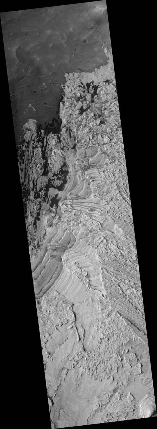
Layers in Becquerel Crater
- Click the image above for a larger view
- Full-Res JPEG (2048 x 5603) (1.3 MB)
- Full-Res TIFF (2048 x 5603) (11.5 MB)
Caption:
The layers shown in this HiRISE image formed by loose sediment accumulating within Becquerel crater. The layers are interesting in that there are repeated cycles of thick and thin layers. These cyclic changes in layer thickness shows that some environmental conditions varied in a repeated way as each subsequent layer was deposited. These variations may be due to annual climate cycles and/or a cyclic variability in the source of the sediment. Most layers are parallel to each other, indicating that deposition occurred by material settling onto the surface. A few layers are cross-bedded, meaning that they are not parallel to the older or younger layers. Cross-bedding indicates that at the time that the layers were deposited, the sediment was transported along the ground surface by wind or water.
Image PSP_001546_2015 was taken by the High Resolution Imaging Science Experiment (HiRISE) camera onboard the Mars Reconnaissance Orbiter spacecraft on November 24, 2006. The complete image is centered at 21.4 degrees latitude, 351.9 degrees East longitude. The range to the target site was 284.1 km (177.6 miles). At this distance the image scale is 28.4 cm/pixel (with 1 x 1 binning) so objects ~85 cm across are resolved. The image shown here has been map-projected to 25 cm/pixel and north is up. The image was taken at a local Mars time of 3:27 PM and the scene is illuminated from the west with a solar incidence angle of 49 degrees, thus the sun was about 41 degrees above the horizon. At a solar longitude of 140.4 degrees, the season on Mars is Northern Summer.
Background Info:
NASA's Jet Propulsion Laboratory, a division of the California Institute of Technology in Pasadena, manages the Mars Reconnaissance Orbiter for NASA's Science Mission Directorate, Washington. Lockheed Martin Space Systems, Denver, is the prime contractor for the project and built the spacecraft. The High Resolution Imaging Science Experiment is operated by the University of Arizona, Tucson, and the instrument was built by Ball Aerospace and Technology Corp., Boulder, Colo.
Cataloging Keywords:
| Name | Value | Additional Values |
|---|---|---|
| Target | Mars | |
| System | ||
| Target Type | Planet | |
| Mission | Mars Reconnaissance Orbiter (MRO) | |
| Instrument Host | Mars Reconnaissance Orbiter | |
| Host Type | Orbiter | |
| Instrument | High Resolution Imaging Science Experiment (HiRISE) | |
| Detector | ||
| Extra Keywords | Crater, Grayscale, Map, Water | |
| Acquisition Date | ||
| Release Date | 2006-12-06 | |
| Date in Caption | 2006-11-24 | |
| Image Credit | NASA/JPL/Univ. of Arizona | |
| Source | photojournal.jpl.nasa.gov/catalog/PIA09381 | |
| Identifier | PIA09381 | |