|
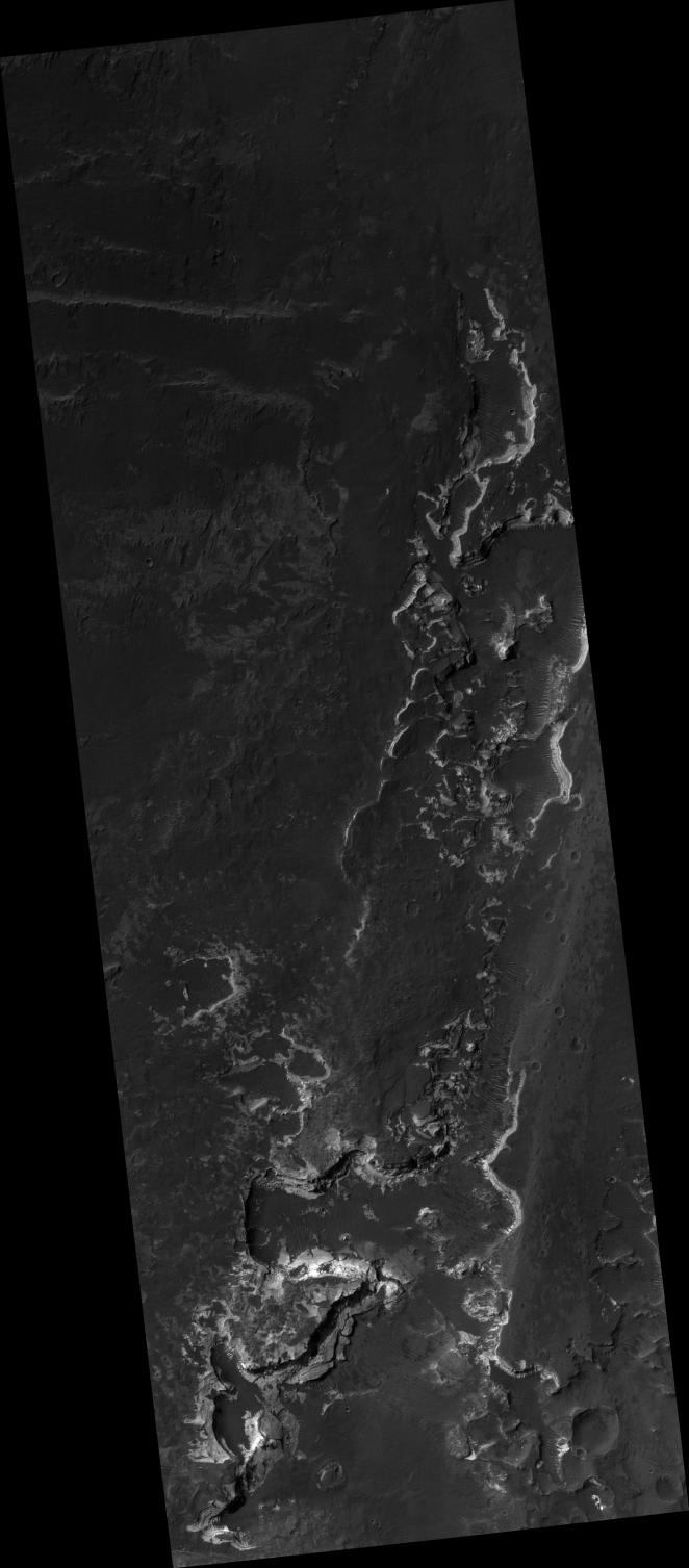
Holden Crater Layers
- Click the image above for a larger view
- Full-Res JPEG (2048 x 4663) (713.7 kB)
- Full-Res TIFF (2048 x 4663) (9.6 MB)
Caption:
This HiRISE image shows fine layers of light-toned rocks on the floor of Holden Crater in Margaritifer Sinus (260S, 3260E). The layers are eroded along elongated north-to-south cliffs that reveal their total thickness approaches 100 meters in some places. Individual layers can be traced for long distances along the cliffs and careful examination shows that some are less than a meter thick and can be distinguished down to the limit of the image resolution. The thickness of individual layers is best distinguished where edge-on views are afforded along large rocks that have fallen off the side of the cliff. Occurrences of such thin, uniform layered rocks that can be traced over large distances are characteristic of layers formed by deposition of sediment in lakes. It has been suggested that a lake once partially filled the crater. The eroded appearance of the layers could be due to both water and wind activity. For example, water flowing through a breach in the southwest rim may have accomplished their erosion. The fresh exposures of the layers and nearby distribution of sand ripples and dunes indicate more recent erosion is the result of wind activity. The presence of these layers that may have been deposited in an ancient lake has contributed to the proposal of this area as a target for exploration by future rovers on the surface of Mars (e.g., the 2009 Mars Science Laboratory ).
Image PSP_001468_1535 was taken by the High Resolution Imaging Science Experiment (HiRISE) camera onboard the Mars Reconnaissance Orbiter spacecraft on November 18, 2006. The complete image is centered at -26.6 degrees latitude, 325.2 degrees East longitude. The range to the target site was 258.6 km (161.6 miles). At this distance the image scale is 25.9 cm/pixel (with 1 x 1 binning) so objects ~78 cm across are resolved. The image shown here has been map-projected to 25 cm/pixel and north is up. The image was taken at a local Mars time of 3:34 PM and the scene is illuminated from the west with a solar incidence angle of 68 degrees, thus the sun was about 22 degrees above the horizon. At a solar longitude of 137.4 degrees, the season on Mars is Northern Summer.
Background Info:
NASA's Jet Propulsion Laboratory, a division of the California Institute of Technology in Pasadena, manages the Mars Reconnaissance Orbiter for NASA's Science Mission Directorate, Washington. Lockheed Martin Space Systems, Denver, is the prime contractor for the project and built the spacecraft. The High Resolution Imaging Science Experiment is operated by the University of Arizona, Tucson, and the instrument was built by Ball Aerospace and Technology Corp., Boulder, Colo.
Cataloging Keywords:
| Name | Value | Additional Values |
|---|---|---|
| Target | Mars | |
| System | ||
| Target Type | Planet | |
| Mission | Mars Reconnaissance Orbiter (MRO) | Mars Science Laboratory (MSL) |
| Instrument Host | Mars Reconnaissance Orbiter | Curiosity Rover |
| Host Type | Orbiter | Rover |
| Instrument | High Resolution Imaging Science Experiment (HiRISE) | |
| Detector | ||
| Extra Keywords | Crater, Dune, Grayscale, Map, Water | |
| Acquisition Date | ||
| Release Date | 2006-12-06 | |
| Date in Caption | 2006-11-18 | |
| Image Credit | NASA/JPL/Univ. of Arizona | |
| Source | photojournal.jpl.nasa.gov/catalog/PIA09382 | |
| Identifier | PIA09382 | |