
|
Bouncing Boulders
- Click the image above for a larger view
- Full-Res JPEG (2048 x 2947) (456.1 kB)
- Full-Res TIFF (2048 x 2947) (6.0 MB)
Caption:
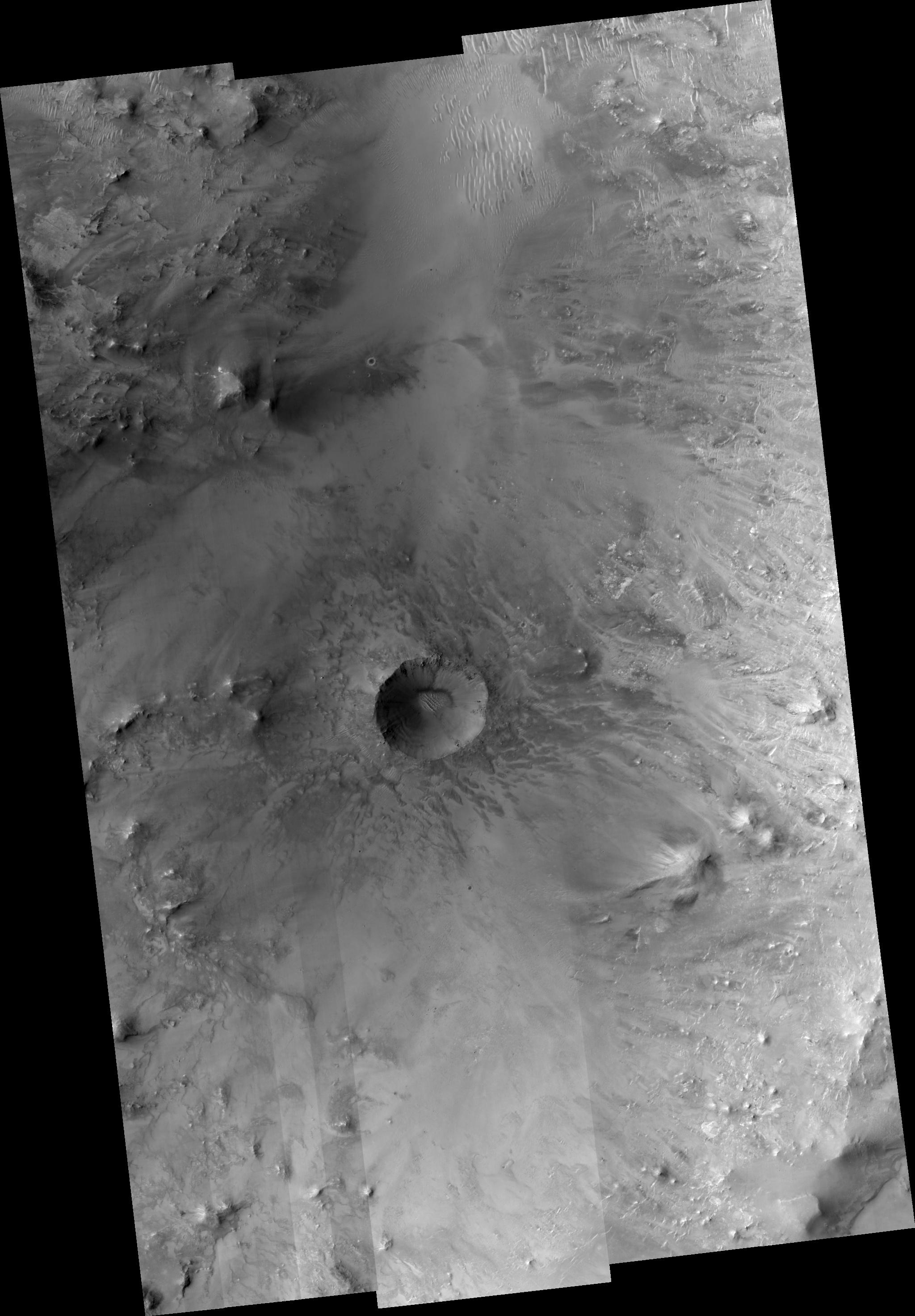
Most debris on crater walls slides straight downhill. In this HiRISE image we see examples of boulders that have bounced downhill, not necessarily vertically.
A prominent example looks like a dotted line from the top of the crater wall where the boulder took off to the crater floor where it finally came to rest.
Numerous boulders have slid partway down toward the crater floor, which is covered by sand dunes. This is actually a small crater (~1 km wide) within an un-named but much larger ~30 km crater.
Observation Geometry
Image
PSP_001385_1985
was taken by the High Resolution Imaging Science Experiment (HiRISE) camera onboard the Mars Reconnaissance Orbiter spacecraft on 12-Nov-2006. The complete image is centered at 18.5 degrees latitude, 65.0 degrees East longitude. The range to the target site was 278.0 km (173.8 miles). At this distance the image scale ranges from 27.8 cm/pixel (with 1 x 1 binning) to 111.3 cm/pixel (with 4 x 4 binning). The image shown here has been map-projected to 25 cm/pixel and north is up. The image was taken at a local Mars time of 03:29 PM and the scene is illuminated from the west with a solar incidence angle of 50 degrees, thus the sun was about 40 degrees above the horizon. At a solar longitude of 134.2 degrees, the season on Mars is Northern Summer.
Background Info:
NASA's Jet Propulsion Laboratory, a division of the California Institute of Technology in Pasadena, manages the Mars Reconnaissance Orbiter for NASA's Science Mission Directorate, Washington. Lockheed Martin Space Systems, Denver, is the prime contractor for the project and built the spacecraft. The High Resolution Imaging Science Experiment is operated by the University of Arizona, Tucson, and the instrument was built by Ball Aerospace and Technology Corp., Boulder, Colo.
Cataloging Keywords:
| Name | Value | Additional Values |
|---|---|---|
| Target | Mars | |
| System | ||
| Target Type | Planet | |
| Mission | Mars Reconnaissance Orbiter (MRO) | |
| Instrument Host | Mars Reconnaissance Orbiter | |
| Host Type | Orbiter | |
| Instrument | High Resolution Imaging Science Experiment (HiRISE) | |
| Detector | ||
| Extra Keywords | Crater, Dune, Grayscale, Map | |
| Acquisition Date | ||
| Release Date | 2007-01-10 | |
| Date in Caption | ||
| Image Credit | NASA/JPL/Univ. of Arizona | |
| Source | photojournal.jpl.nasa.gov/catalog/PIA09564 | |
| Identifier | PIA09564 | |